Newcastle City Council is after feedback about your experience of walking and cycling around Newcastle and how that experience could be improved. This might include better pavements, better crossings, more space for cycling, improved junctions, lower vehicle speeds or less traffic.
This is being done in support of the national Cycling and Walking Investment Strategy, which outlines the Government’s ambition “to make cycling and walking a natural choice for shorter journeys, or as part of longer journeys by 2040”. Ultimately this should result in a network of good quality walking and cycling routes where people feel safe and which can be used by all ages and abilities.
Please take a few minutes to share your thoughts and ideas on the consultation website. Please do also read through comments other people have made about the routes you use and, if you agree, ‘like’ those comments to show your agreement. Every comment or like is a piece of evidence the Council can use to determine what improvements are most needed and the order in which they should be implemented.
The consultation is open until 8 March 2019. There are drop-in events too during February.
How will this feedback be used?
The rest of this blog is to explain the process from gathering information in the above consultation through to the creation of a prioritised list of improvements that together will form the Newcastle Local Cycling and Walking Infrastructure Plan (LCWIP). This is based on the Government’s LCWIP Technical Guidance.
Newcastle is one of 38 Local Authorities that have been asked by the Government to produce a Local Cycling and Walking Infrastructure Plan.
The Government’s LCWIP Objectives
These are the objectives included in the LCWIP technical guidance that set out for Local Authorities what each LCWIP should aim to achieve.
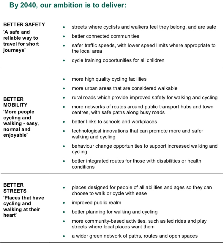
These align with SPACE for Gosforth’s own aims for healthy, liveable, accessible and safe neighbourhoods.
Key amongst these are “streets where cyclists and walkers feel they belong, and are safe”, “places designed for people of all abilities and ages so they can choose to walk or cycle with ease”, and “more networks of routes around public transport hubs and town centres, with safe paths along busy roads”.
Process
The technical guidance also sets out the process in which the key actives are network planning for walking and network planning for cycling, which we will focus on below.
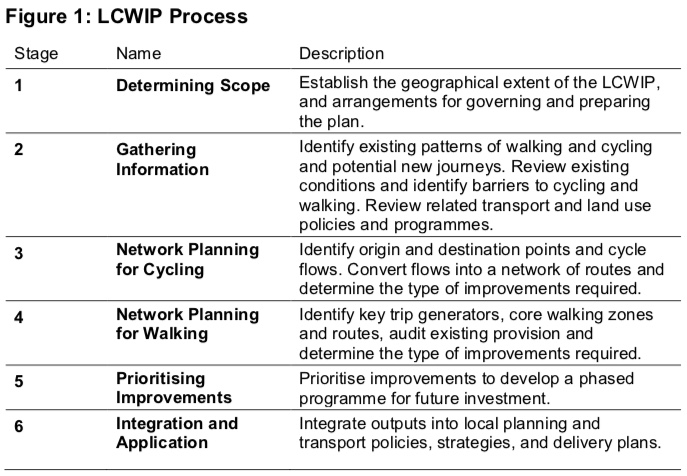
Planning for public and stakeholder engagement is part of stage 1.
Gathering Information
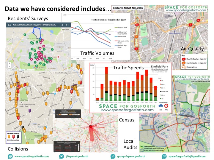
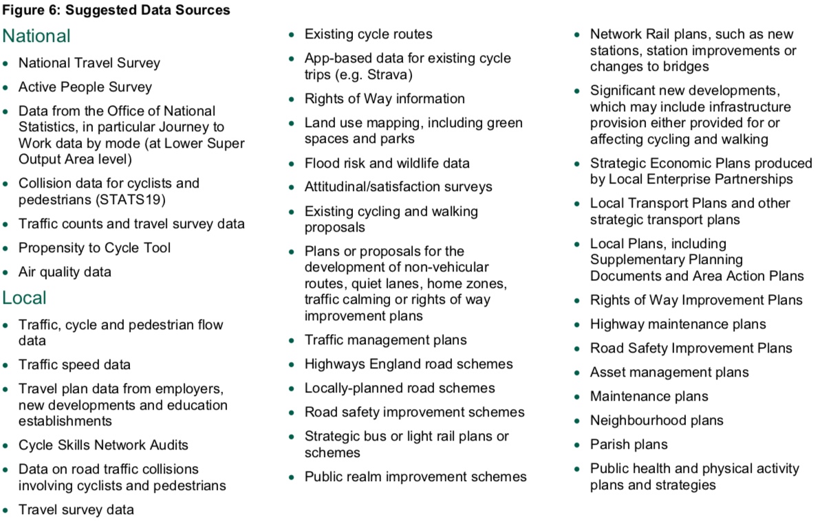
The LCWIP guidance identifies a range of data sources, many of which SPACE for Gosforth has already looked at including traffic volumes and speeds, air quality and collision data. Newcastle City Council has also commissioned its own surveys including the Bike Life Report and sought residents input via its Streets for People project covering Jesmond, Heaton and Ouseburn, Arthurs Hill and Fenham. Information from the consultation referenced at the top of this blog will also be fed into the process.
Network Planning – Origins and Destinations
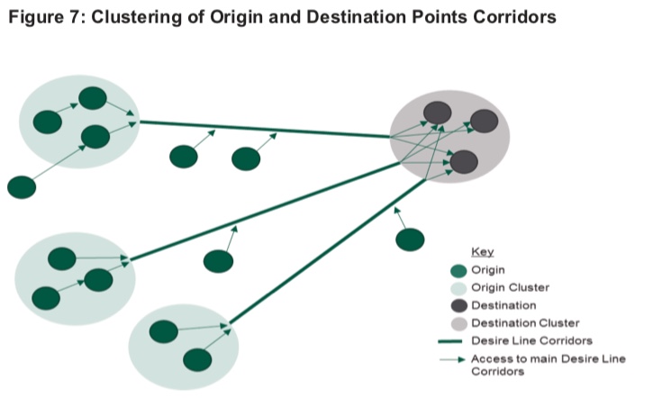
Network planning for walking and cycling are similar in that both require the identification of origins and destinations. Typically origins will be residential areas and destinations will be shops, schools, workplaces and transport hubs. The walking and cycling networks should support journeys from residential areas to destinations but also between destinations e.g. for someone walking or cycling from the offices at Regent Centre to the High Street for their lunch.

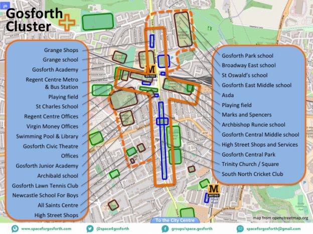
Once origins and destinations have been determined, the next step is to group those that are close together e.g. Gosforth library, swimming pool and Regent Centre offices might all be in one cluster.
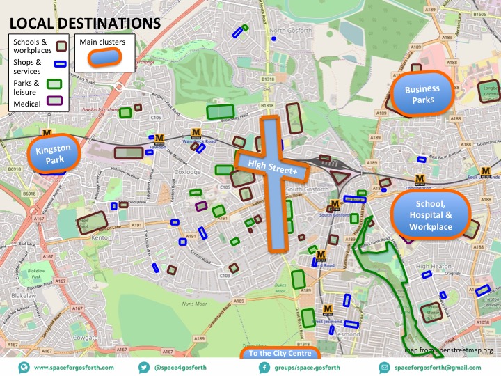
We have created a map of destinations for Gosforth. If you think we have missed any destinations please let us know via the comments below.
Core Walking Zones and Key Walking Routes
To determine where to focus walking improvement, the technical guidance suggests identifying Core Walking Zones, which are locations where there are multiple destinations in the same area.
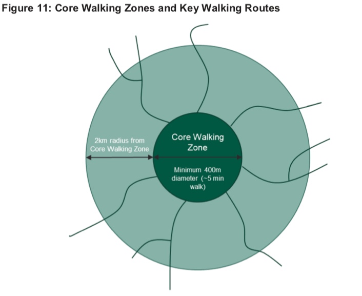
Having identified the core walking zones, the next steps are to identify the main current and potential walking routes to and from the core walking zones. Part of the analysis is to look at ‘severance’ where a walking route has a dog-leg as a result of some sort of barrier, which in Gosforth might include Metro lines, boundaries of housing estates and the Town Moor. Potential improvements to reduce severance might include new footpaths or a new bridge over the Metro line.
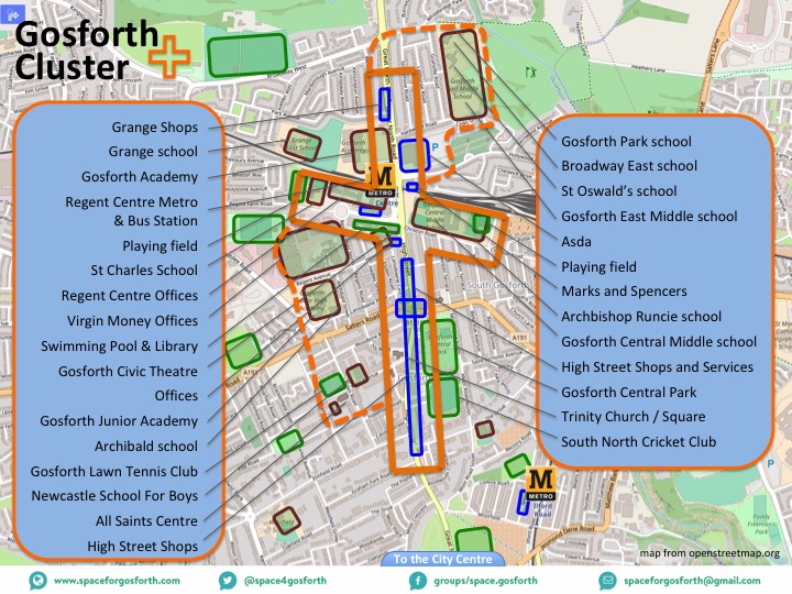
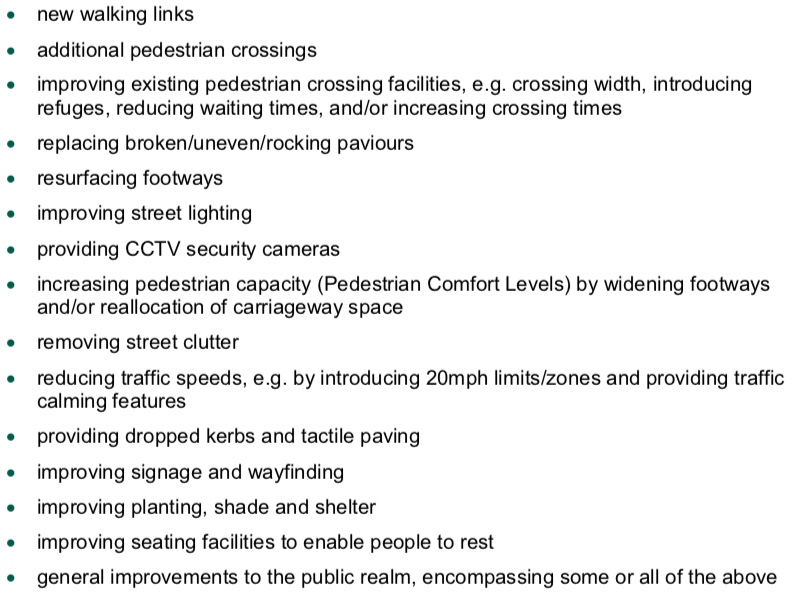
The diagram below shows the SPACE for Gosforth proposal for a Gosforth High Street “Core Walking Zone” and other nearby destinations. Potential improvements for walking are listed at the end of this blog but for the High Street could include removing street clutter, additional planting or seating, and reducing traffic speeds.
Network Planning for Cycling
For cycling, the aim is to create a network of routes that connect origins and destinations, with the aim that adjacent routes within the network should not be any more than 400m apart. Routes should be of a consistent quality so that they can be used by all ages and abilities.
We set out the process for creating a cycling network in our SPACE for Gosforth blog: Building a Safe Cycling Network for Gosforth. The LCWIP process is very similar to this. The key stages are:
- Identifying and grouping origins and destinations.
- Identifying desire lines between origins and destinations.
- Converting desire lines into preferred routes.
- Considering additional requirements such as signage and cycle parking.
We have used the Government guidance to produce what a potential cycle network map covering Gosforth and nearby areas could look like.
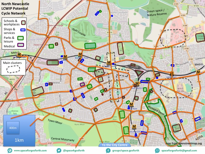
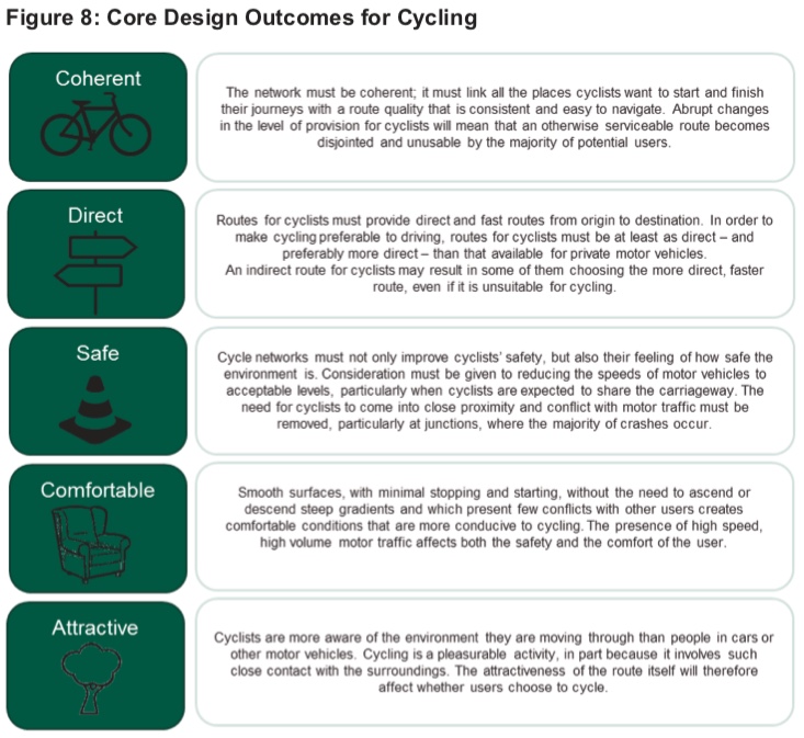
Any routes proposed, including those in the map above, would need to be assessed against the following specified design standards.
- Coherent: i.e. to be of consistent quality, easy to navigate and linking places where people want to go, such as the local destinations on the map above.
- Direct: to encourage people to use the routes rather than shorter alternatives that may not be so suitable for cycling and “to make cycling preferable to driving“.
- Safe: especially reducing vehicle speeds and removing the need for people cycling to come into close proximity with motor traffic.
- Comfortable: minimal stopping and starting and avoiding conflict with other road users.
- Attractive.
The guidance also states that “As well as the key routes that join origin and destination points, there is a wider network of quiet streets. While it can be assumed that conditions generally are acceptable for cycling due to lower speeds and volumes of motor traffic, some routes will require infrastructure improvements. For example at junctions with busy roads, or to cross physical barriers such as rivers, canals and railway lines.”
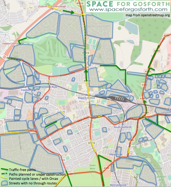
We can see in Gosforth that the network developed so far falls short of these measures, for example on the Great North Road and Gosforth High Street there are a wide variety of different route types some of which involve cycling in heavy traffic.
In our blog Building a Safe Cycling Network for Gosforth we included the following assessment showing protected / traffic-free cycling routes in green and low-traffic neighbourhoods enclosed in blue. It is clear from this that there is a substantial amount to do in Gosforth to meet the Government’s ambition for cycling to be a natural choice for shorter journeys.
Prioritisation and Local Policy
The final stages of the LCWIP cover prioritisation of improvements based on ease of implementation and likely benefit, and embedding the LCWIP into Council policy.
The LCWIP is already referenced in the Council’s Development and Allocation Plan, which SPACE for Gosforth has written about previously, and once the LCWIP has been produced, new developments will be required to link into the LCWIP walking and cycling networks.
Please don’t forget to add your comments!
Appendices
A – Potential Improvements for Walking
B – Potential Data Sources for the Information Gathering Stage
C – Core Design Outcomes for Cycling (and Walking)

At the moment, with Salter’ s Bridge closed, Hollywood Ave is being used by a lot more cyclists. I have seen posts recommending people cycle that way to the coast from Gosforth as it is quiet and pleasant to cycle as well as convenient and relatively free of traffic. If Salters Bridge were to remain closed this could be an important cycling route.
Before you invest in any further development – repair the existing broken and uneven pavements
Repair the roads – not just a patch but a proper resurface