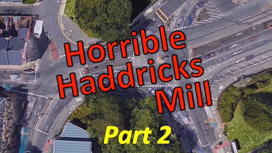
In our previous blog on Horrible Haddricks Mill, we set out how we had written to the Council to set out our concerns about safety, poor quality of the design and potential negative impact, especially on older or visually impaired people.
We know from our own measurements that there is space for separate, good quality walking and cycling provision at Haddricks Mill, but that the Council has chosen, contrary to its own policy and legal obligation to reduce air pollution, to prioritise high-speed and potentially dangerous vehicle movements instead.
In speaking to the Council, the Council gave a number of reasons why they believe that shared pavements and indirect wiggly walking and cycling routes via multi-stage crossings are appropriate.
These reasons were:
- People walking or cycling can use alternative routes.
- The junction needs to have wide lanes for buses and freight.
- There isn’t space on the bridge for a pavement and cycle lanes.
- There isn’t enough space on the approach roads.
- Traffic Management is needed to improve air quality.
We have examined and responded to each of these reasons below.
1. People walking or cycling can use alternative routes.
One argument was that walking and cycling would be better provided for using alternative routes.
Haddricks Mill itself is a key crossing of the Ouseburn, which creates a bit of a barrier for east – west travel in the city. The junction is key not just for vehicle traffic but also for walking and cycling.
We looked at the other options for crossing the Ouseburn, and while there are more options for walking and cycling, most are not suitable after dark and the existing provision for walking and cycling is poor.
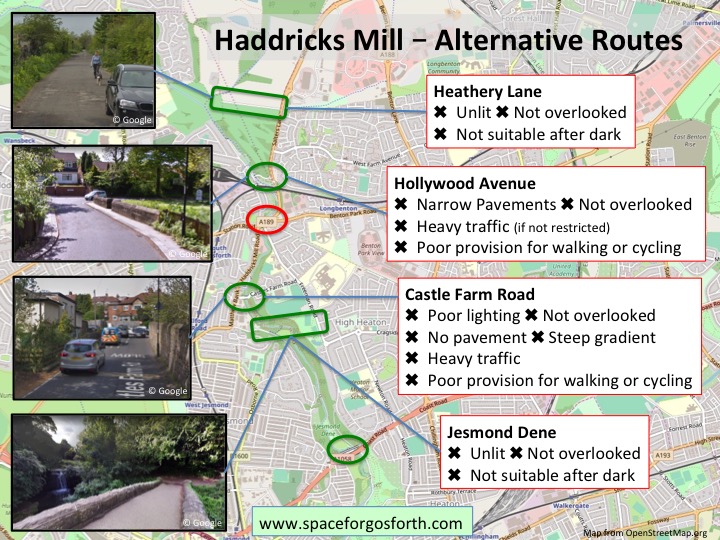
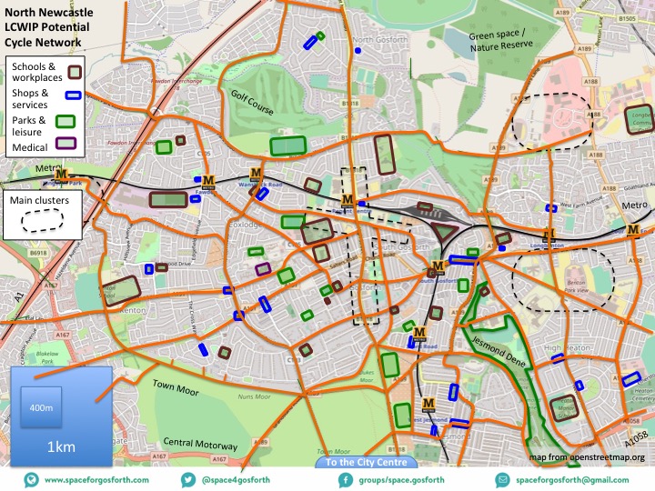
The route map below is from the SPACE for Gosforth blog A Cycling and Walking Infrastructure Plan for Gosforth. In that blog we set out how walking and cycling networks need to connect people to destinations, and that adjacent routes should not be too far apart. Government guidance for cycling is that adjacent routes should be about 400m apart which means that all the routes highlighted above need to be upgraded rather than considering them as alternatives.
2. The junction needs to have wide lanes for buses and freight
Clearly Haddricks Mill is used by buses and for local freight, but there is a question of how and to what extent that should influence the design.
The Council’s own Core Strategy includes a hierarchy of sustainable modes of transport where walking and cycling are placed ahead of buses and freight as well as ‘protecting and enhancing pedestrian routes, cycle networks and Rights of Way’.
In addition, the Council’s Development and Allocations Plan confirms that on main roads ‘Pedestrian and cycle movements should be segregated from traffic’ and that ‘routes must be legible, inviting, direct, pleasant and easy to use’. Other than for a short distance on Haddricks Mill Road where the Council is proposing separate walking and cycling routes, the current Haddricks Mill proposal fails on all five counts.
The North East Freight Partnership publishes route maps that it expects freight organisations to use wherever possible. These routes are shown as dashed lines on the map below. These show that Haddricks Mill, the double circle in the centre of the map, is not on any designated freight route.
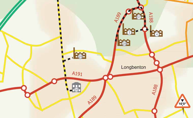
Freight Route map showing routes to Gosforth Industrial Estate (29), Gosforth High Street (30) and to Balliol (3), Quorum (4) and Gosforth (28) business parks.
For buses we looked at the turn from Freeman Road left towards Station Road as an example. There are about five buses an hour that make this movement.
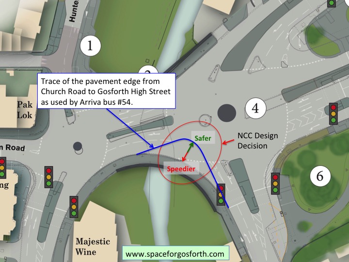
In the Council’s proposal the road retains a wide sweep which means vehicles, including buses, can travel around the corner at a relatively high speed. When designing for safety it is generally understood that a tighter curve prevents higher speeds and therefore avoids the most serious collisions. Because of the poor quality of proposals a large proportion of people who currently cycle are likely to continue to use the road so would be put at risk by this proposal.
In the diagram below we have compared the turn at Haddricks Mill with the turn from Church Road to Gosforth High Street, which is the route taken by the number 54 bus. While it might not be desirable to use exactly this geometry, it certainly demonstrates that the turn could be substantially tighter, and safer, than is currently proposed. If this was done it would create additional space that could be used for separate walking and cycling routes.
What would be more useful for buses would be to introduce bus lanes on Haddricks Mill Road and Benton Park Road to allow buses to get ahead of queuing traffic. This would also assist air quality as buses would not have to wait for so long to pass through the junction.
3. There isn’t space on the bridge for a pavement and cycle lanes.
The bridge across the Ouseburn has been quoted as the narrowed part of the junction but even here it would be possible to include separate walking and cycling lanes.
Measuring on Google Earth the width of the bridge looks to be close to 23m at its narrowest point including current pavements. Using the StreetMix website we can see that it would be possible, shown in the diagram below, to have two 1.8m pavements, two 3m bi-directional cycle lanes and four 3.2m traffic lanes.
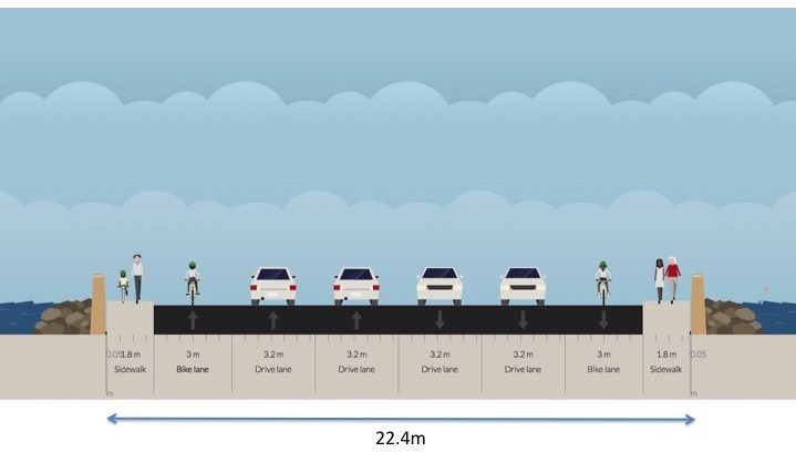 If the western roundabout was made single-lane then only one west bound vehicle lane would be required creating even more space for additional pavement or possibly a verge between the cycle lane and traffic.
Having less sweeping entry lanes would also reduce the additional distance people will have to walk when going around the junction.
4. There isn’t enough space on the approach roads
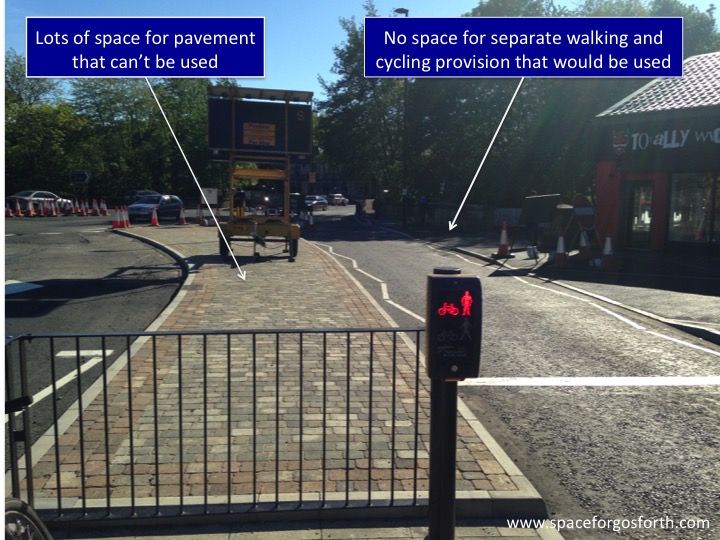
The picture below that we shared in our blog Must do better about the Killingworth Road road works, shows just how much space is being taken up by the central crossing islands. If the crossings were made to be single-stage there would be plenty of space for good quality separate walking and cycling routes.
The use of multi-stage crossings is not to benefit people walking or cycling. The purpose instead is to prioritise traffic movement, with ‘sheep pens’ in the middle of the road to prevent people walking from using the most obvious direct route. In practice many people will just ignore the lights and cross directly to the pavement in the middle of the picture, and in fact several did so just in the few minutes while I was there taking the picture.
On Benton Park Road, on the approach to the roundabout, the proposed west-bound lanes by themselves take up over 12m so to suggest there is no space for an all age and ability protected cycle lane there is completely ridiculous.
5. Traffic Management is needed to improve air quality
The Council have also argued that increasing the vehicle capacity of the junction will improve air quality. We can see how the Council might justify this via their transport models but the outputs for such models almost entirely depend on getting the right inputs, in this case how many vehicles will use the junction after capacity is increased. If the capacity is used up, as is usually the case in practice, then queuing times remain as they are, only with a greater number of vehicles emitting a larger amount of pollution.
Even the Government has cast doubt on the effectiveness of traffic management, such as is proposed at Haddricks Mill, to reduce air pollution. The only really effective ways of reducing pollution are cleaner engines and reducing the number of vehicles. The main effect of the approach proposed by the Council, using the “pedestrian” lights to hold back traffic so traffic arriving from other directions can enter the junction, will be to make it slower and less attractive to walk or cycle. As a result more people will choose to drive.
Our biggest concern for pollution however is Station Road, which had illegal air pollution prior to the roadworks, and would be likely to return to illegal levels of air pollution now Killingworth Road has re-opened to traffic. The Council’s most recent update to its air pollution plans include no measures to reduce pollution on Station Road.
Killingworth Road itself should benefit from having a wider road that allows pollution to dissipate more quickly, and a new bus lane that means buses do not have to queue for so long.
Fears pollution levels will be dangerously high again at controversial Killingworth Roadhttps://t.co/eAJBUIAUOb
— The Chronicle (@ChronicleLive) June 4, 2019
The table below shows the impact of closing Killingworth Road to air pollution on Station Road, and also at North Tyneside’s Longbenton monitoring sites.
 Although people assume that traffic, and therefore pollution, will have increased on the Great North Road and Benton Road, monitoring data suggests that actually traffic levels did not change as a result of the roadworks. This effect, described as ‘Disappearing Traffic‘, which means that large parts of the Killingworth Road traffic disappeared rather than re-routing, almost certainly explains the slight decrease in pollution levels in Longbenton during the road works.
Next steps
The Council say they want to encourage more people to walk or cycle as an alternative to driving. Building junctions that prioritise traffic volume over people’s safety is not the way to achieve it.
SPACE for Gosforth has shared this analysis with the Council’s transport team.

We generally have to accept that Newcastle council has proved it will not priorities anything other than car and has no either inclination nor desire nor intelligence outside of its traditional none working box’s…. therefore maybe more direct legal challenges may should be looked into . Court action and incompetence in public office endangering public life etc
I witnessed a strange sight today – cyclists actually using a cycle path – the car is here to stay so for the majority the roads should be for motorists – the council is bothered about air pollution – they have given planning for 8000 houses north of Gosforth- so the traffic and pollution is going to increase
Your campaign should be for better roads and bypasses to these highly polluted areas
We have spoken to Highways England about their plans to add a lane to the A1 north of the Tyne, in effect a bypass for Newcastle. They told us that doing so would make practically no difference at all to traffic levels in Gosforth, and actually I suspect they are being optimistic as it could lead to more people driving overall. If your objective is to reduce pollution then the £150m+ planned for the bypass could be spent much more effectively and would be more than sufficient to cover the many more effective measures that we have proposed.