
Newcastle City Council is seeking feedback on new proposals intended to “improve road safety, create better public transport links and encourage walking and cycling” in and around Gosforth High Street. This is an informal consultation and a further formal consultation will be required before any of these plans are implemented.
Councillor Sathian, cabinet member for climate and transport is quoted in the Council’s news release saying “With limited space, we’ve developed a set of measures that improve cycling connections, enhances spaces for walking, and make the area safer – particularly for the many school children who travel in this area daily.”
You can see the Council’s brochure describing the proposals and provide feedback until 27 April 2025 at: https://www.letstalknewcastle.co.uk/consultations/544/participate.
There are also two drop-in sessions:.
- Wednesday 2 April – 3 till 6pm – in Trinity Church, High Street, Gosforth (access via the café)
- Monday 7 April – 5 till 8pm – in Café 1901, Trinity Church, High Street, Gosforth
Below we give SPACE for Gosforth’s initial view and describe the proposals, which are split into five sections, or areas, between Little Moor and Regent Centre. We will follow this up with a more detailed response in the next few weeks.
The SPACE for Gosforth View
Fundamentally Newcastle City Council needs to decide if it wants Gosforth High Street to be the centre of our local community, or if it will continue to treat it as it does now as an inconvenient obstacle to passing traffic.
There have been multiple consultations on Gosforth High Street and every time residents have fed back that they want a vibrant community destination. Instead, we’ve got a dangerous multi-lane highway where pedestrians must wait ever longer to cross the road and people cycling are advised to steer clear altogether.
While the new proposals will help people walking and cycling away from the High Street, the detail shows that on the High Street itself, one of the most useful pedestrian crossings by The Grove is being removed and over twice as much cycle lane is being removed as is being added. Meanwhile, the Council appears to have dropped proposals to address long-standing safety issues on busy side streets like Linden Road and The Grove, that children use to travel to school.
The one proposal that bucks this trend is the new protected cycle lane to allow families with children to cross the High Street to and from Gosforth Central Park. This needs to be expanded so it can also be used by customers who cycle to access shops and services right along the High Street.
This needs serious political leadership, not just from the cabinet member for transport but also from local Councillors, to make Gosforth High Street the safe, attractive and accessible destination the community desires.
Area 1 – Moorfield to Moor Road South junction
Area 1 proposals are for two alternative options to reduce traffic on Moor Road South and Moorfield in High West Jesmond to make it safer for people to walk or cycle.
Based on 2023 traffic counts, about three quarters of traffic travelling south on Moor Road South and one quarter of traffic travelling west on Moorfield exits onto Great North Road.
Based on Active Travel England ratings which take into account traffic volumes and speed, Moorfield is currently ‘suitable for most’ (but not all) people cycling. Moor Road South is ‘suitable for few’ i.e. most people would not currently be willing to cycle on Moor Road South because of the volume and speed of traffic. The same is true of Linden Road to the west of Gosforth High Street. There are also multiple issues for pedestrians on Moor Road South, like no dropped kerbs.
We looked at options to resolve traffic-related issues in our 2019 blog East Gosforth – Streets for People.
Option 1 would stop motor traffic exiting from Moorfield onto the Great North Road.
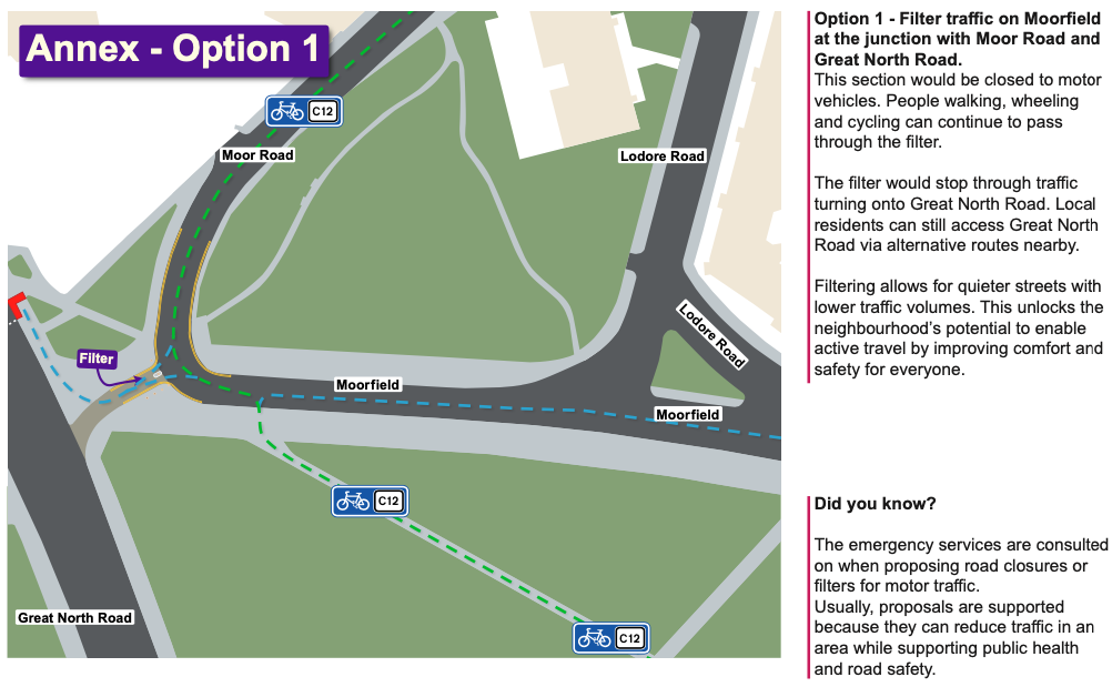
Screenshot from the Council’s explanatory pamphlet
Option 2 would stop motor traffic between Moor Road South and Moorfield, but traffic from Moor Road South would still be able to exit onto Great North Road.
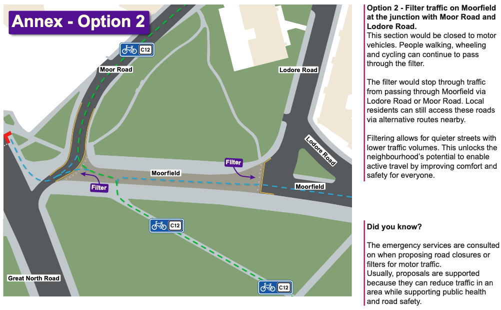
Screenshot from the Council’s explanatory pamphlet
Area 2 – Moorfield to Causey Street
Area 2 proposals are:
- Removal of the pedestrian refuge between Elmfield Road and the Grove.
- A new bus lane between Graham Park Road and Elmfield Road.
- A new pedestrian crossing between Rosewood Avenue and Graham Park Road.
The right turn lane into The Grove will also be removed as there is not space to retain this with the bus lane.
No improvements are planned for the crossing between Moorfield and Moor Crescent, nor to the current painted cycle lane.
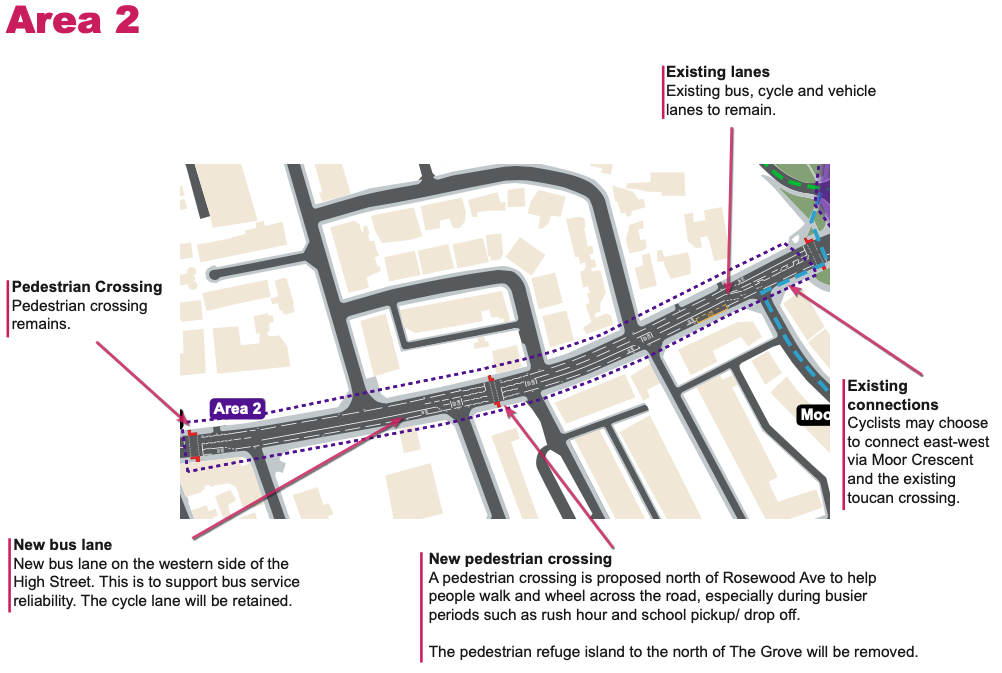
Screenshot from the Council’s explanatory pamphlet
If the proposed changes go ahead, the refuge shown in the picture below will be removed so that the Council can extend the bus lane. The aim of the bus lane is to save time for people on the bus, but this will be at the expense of people walking from Elmfield to The Grove who will have to use the pedestrian crossing by Causey Street instead.
The crossing proposed to be removed.
One alternative might be to move the current crossing north of Elmfield Road to where the pedestrian refuge is now, to enable people walking or cycling to cross between Elmfield Road and The Grove.
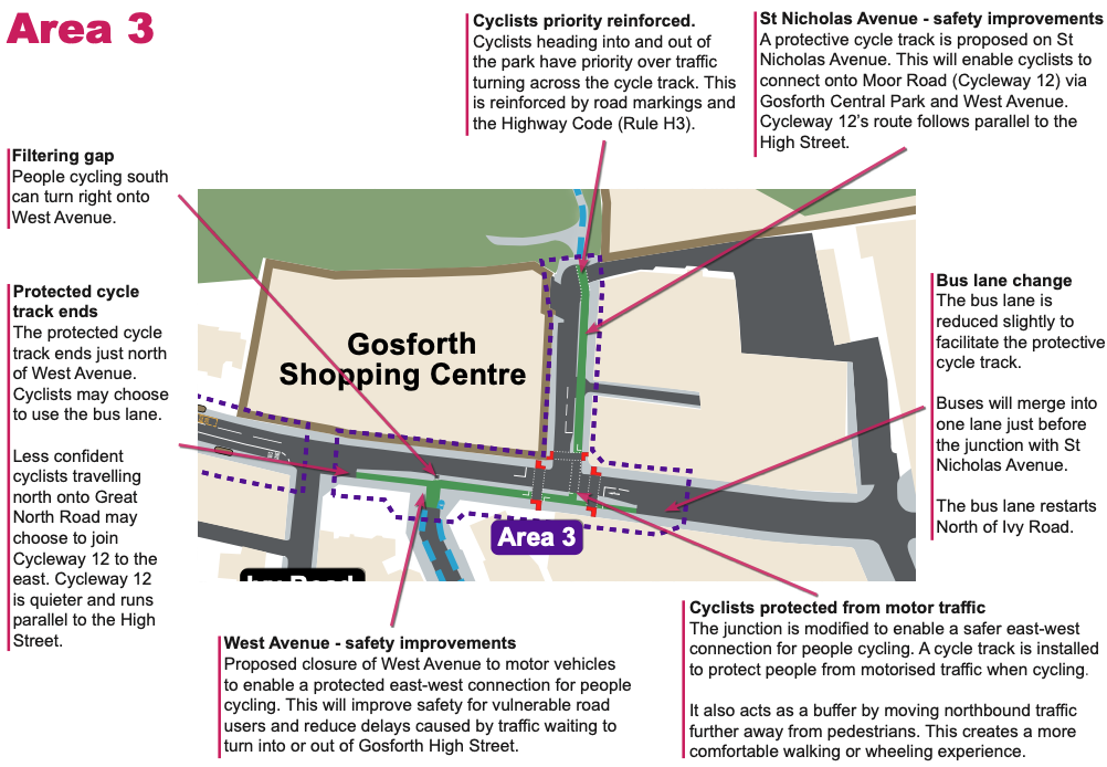
Area 3 – Gosforth Shopping Centre
Area 3 proposals are:
- A new two-way protected cycle track on the south side of St Nicholas Avenue between Gosforth Central Park and Gosforth High Street. This would replace the current parking and taxi rank.
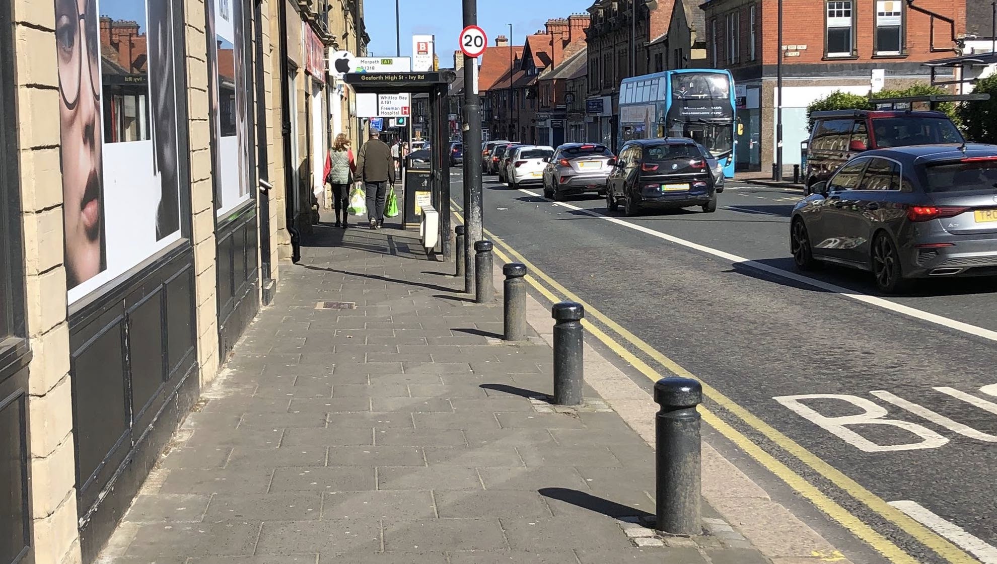
- A cycle crossing to a new two-way protected cycle track on the west side of Gosforth High Street between St Nicholas Avenue and just south of Ivy Road, replacing approximately 50m of the current bus lane.
- No exit or entry for motor vehicles from West Avenue onto Gosforth High Street.
The Council have also confirmed they plan to remove the south-bound cycle lane on the east of the High Street from Church Road to St Nicholas Avenue. This is counter to the LTN1/20 guidelines which Newcastle City claim to have adopted which says “Cyclists must be physically separated and protected from high volume motor traffic, both at junctions and on the stretches of road between them” and “Cycle networks should be planned and designed to allow people to reach their day to day destinations” like Gosforth High Street.
The crossing by Ivy Road to the Shopping Centre will be retained.
Screenshot from the Council’s explanatory pamphlet
This short section of bus lane would be replaced by a two-way cycle track to enable people cycling to cross safely from West Avenue to Gosforth Central Park and vice versa.
Area 4 – Ivy Road to Salters Road
Area 4 proposals are:
- Removal of the south bound cycle lane between Salters Road and St Nicholas Avenue.
- A wider pavement between Ivy Road and Woodbine Avenue.
- For north-bound traffic, the left lane at the Salters Road junction will become left turn only. The right-hand lane will be for vehicles going straight on or turning right.
Currently south-bound buses and vans delivering to the shops stop in the cycle lane. This means other vehicles can pass them without encroaching on the north-bound lane. This will no longer be possible.
The Council say they don’t plan to have separate north and south-bound phases at the Salters Road traffic lights, but this would be subject to traffic modelling. The prohibited right turn from Great North Road to Salters Road will remain prohibited.
Screenshot from the Council’s explanatory pamphlet
The pavement between Ivy Road and Woodbine Road would be widened with the south-bound cycle lane removed.
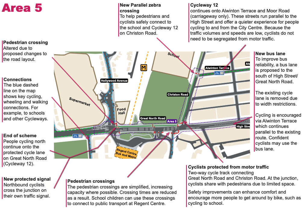
Area 5 – Salters Road to Regent Centre
Area 5 proposals are:
- Removal of the north-bound protected cycle lane between Salters Road and Regent Centre.
- This will be replaced by a new north-bound bus lane between Salters Road and Henry Street.
- The south-bound cycle lane between Hollywood Avenue and Christon Road will become two-way.
- A new separate cycling phase at the Regent Centre traffic lights will allow people cycling north to cross diagonally to join the existing cycle track past Gosforth Academy.
- A new two-way traffic-free cycle track along Christon Road between Great North Road and Alwinton Terrace, achieved by reducing the width of the current verge. This will connect to Gosforth Central Middle School, but will stop before Archbishop Runcie First School.
- A parallel zebra crossing over Christon Road between the cycle track and Alwinton Terrace.
- Removing the ‘sheep pen’ in the Great North Road pedestrian crossing by Christon Road so people can cross in one go.
The Council states that “Cycleway 12 continues onto Alwinton Terrace and Moor Road (carriageway only). These streets run parallel to the High Street and offer a quieter experience for people cycling to and from the City Centre. Because the traffic volumes and speeds are low, cyclists do not need to be segregated from motor traffic.” However we know from recent Council traffic speed and volume counts that Moor Road has too much traffic to be considered suitable as an all-ability cycle route.
Also LTN1/20 recommends a spacing of 250-400m between parallel routes, which suggests both Gosforth High Street and Moor Road should be made suitable for cycling. It also states cycle routes should be “at least as direct – and preferably more direct – than those available for motor vehicles.”
The Council have separately told us these proposals will require removal of the kerb separating north and south-bound traffic between Christon Road and Regent Centre. The Council intend to retain if possible the central kerb between Christon Road and Henry Street which prevents south-bound traffic turning right into Henry Street.
Screenshot from the Council’s explanatory pamphlet
The north-bound protected cycle lane from Salters Road to Regent Centre (approx 500m) will be removed.
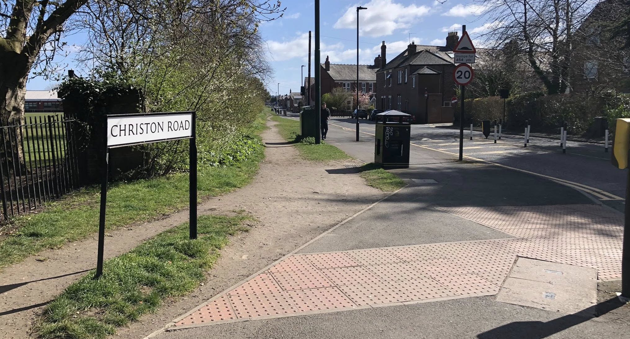
A new cycle lane will be created along Christon Road using space from the current verge.
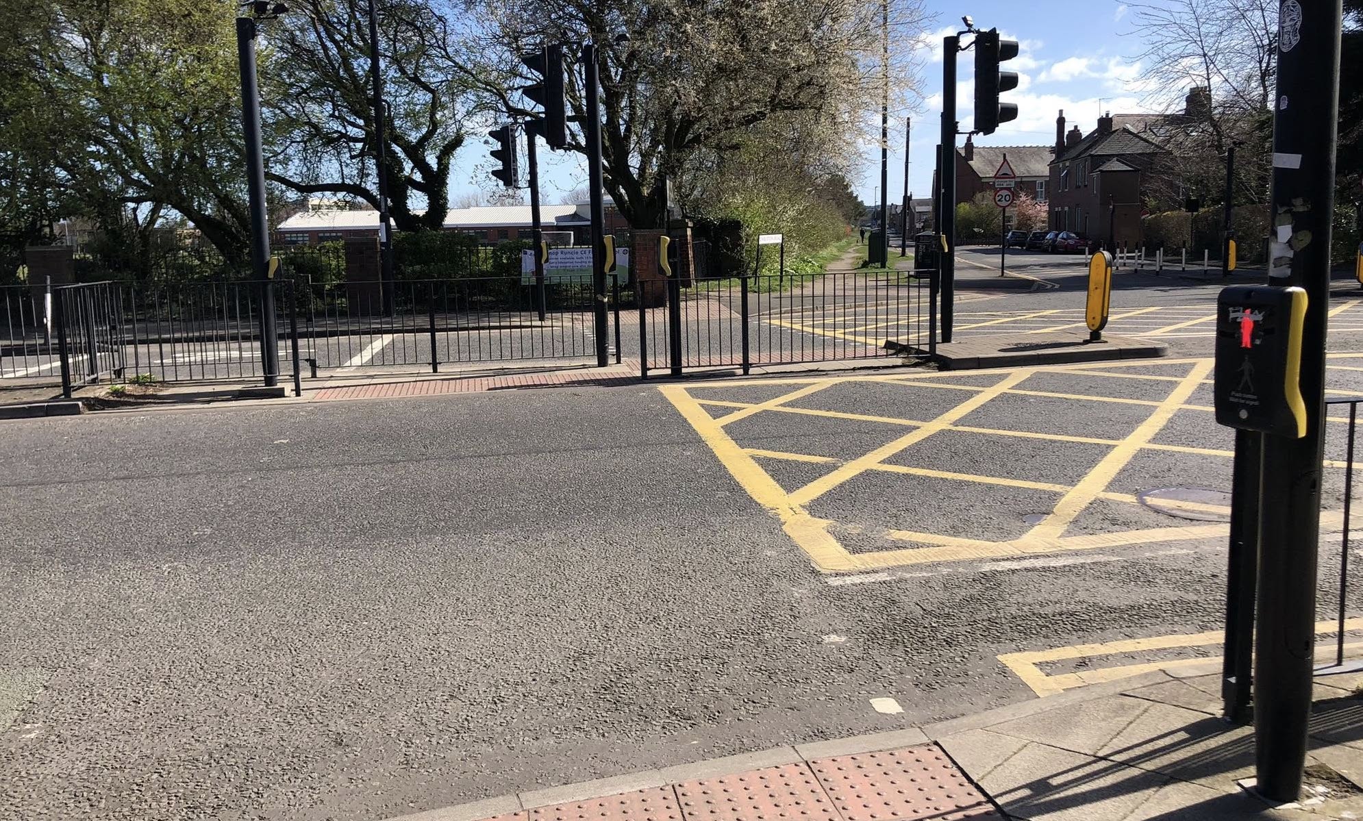
The central island will be removed and pedestrians will be able to cross all four lanes in one go.
In 2019 SPACE for Gosforth set out proposals to improve walking and cycling near Regent Centre, including a new straight-over crossing (as proposed by the Council) and a cycle lane on Christon Road connecting to Archbishop Runcie First School.
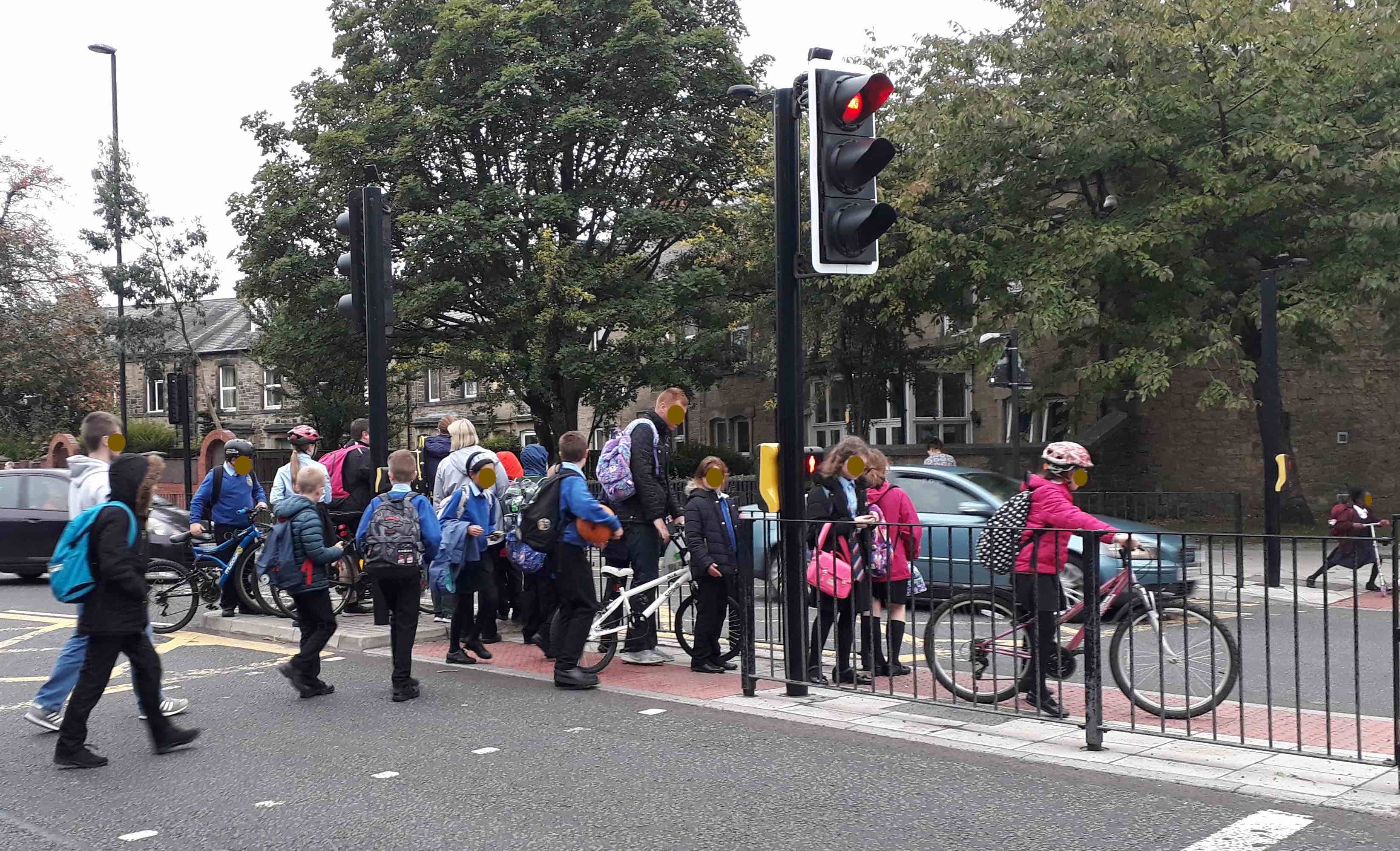
Photo from the SPACE for Gosforth Regent Centre blog showing children crossing the Great North Road.
You can provide feedback on the proposals until 27 April 2025 at: https://www.letstalknewcastle.co.uk/consultations/544/participate.
The proposal to close West Avenue at the High Street end is foolish indeed. It will create a clogged rat run along Ivy Road, a street with a narrow and dangerous bend. It would be better to close streets either side of Trinity Church to create a big ‘town square’ full of planters and seats. Alternatively both streets might be made alternate one way. The scheme is too piecemeal. The biggest problem for pedestrians, long waits at the main crossings is wrongly ignored.