
Earlier this year, Newcastle City Council updated its proposals for High West Jesmond as part of the overall Jesmond Streets for People plans. The council signalled that it was considering other options for how the budget might be used to improve walking and cycling.
The new plans published in March are set out on the High West Jesmond Residents’ website. This blog is about SPACE for Gosforth’s input to the process, which was shared with the Council at the end of March 2019. The original scheme is (at the time of writing) still available on the Streets for People website.
In this proposal we have considered a wider area bounded by Gosforth High Street, Church Road/Station Road and Haddricks Mill Road/Jesmond Dene Road, rather than just High West Jesmond. Looking at one area in isolation would have the potential to push traffic onto other residential streets, whereas looking at a wider area helps to avoid this.
We are sharing this as a draft and would welcome any feedback on the proposal itself and on the approach taken, which we have explained below. Although we don’t have detailed costings, our belief is that what we have proposed would lead to much greater benefits over a wider area at a much reduced cost, and at the same time would minimise the impact on residents who do need to drive for some journeys.
Streets for People – High West Jesmond
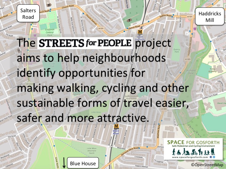
The Streets for People project overall aims to enable more people to walk and cycle in three areas, each of which has a budget of £1m funded by a grant from the Department of Transport’s Cycle City Ambition Fund.
The Council’s new proposals retain the cycle lane on Ilford Road between Moorfield and Jesmond Dene Road but other than that seem to have little benefit for walking or cycling. We were surprised the Ilford Road cycle lane was included in the Streets for People proposals as it was part of the recommendations from the Blue House working group so we expected it would be funded from that budget rather than diluting the Streets for People funding.
The other new proposals were to include speed bumps on Moorfield and at the junction with Ilford Road and continuous pavement on the north side of Moorfield. Based on experience elsewhere in Gosforth (Hollywood Avenue, Regent Farm Road), we wouldn’t expect speed bumps by themsleves to make any great difference to the liveability or safety of the street. Continuous pavement is usually used along main roads so may have the opposite effect and encourate people to believe that Moorfield is to be used as a main road for through traffic.
Issues and Concerns
There is a reasonable amount of data to describe issues in the area east of Gosforth High Street, including high or illegal levels of air quality on the surrounding main roads, and high volumes of traffic, much of which is speeding, on residential streets.
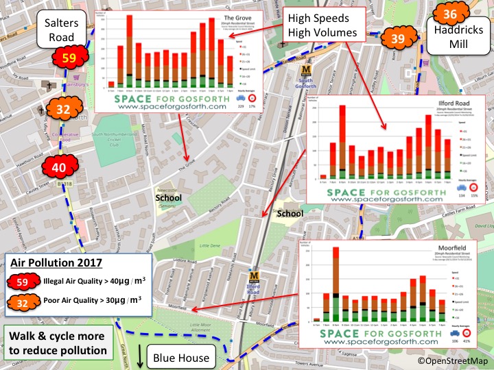
This data is backed up by comments shared by residents during the Streets for People and Local Cycling and Walking Infrastructure Plan (LCWIP) consultations. Ilford Road, Moorfield and Moor Road South are frequently mentioned as problem streets with high traffic volumes and speeding.
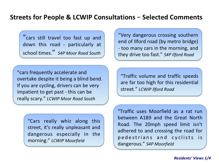
High West Jesmond Residents’ Group held a meeting that resulted in similar comments shown in the slide below. This we previously reported in the SPACE for Gosforth blog about the original proposals. High West Jesmond Residents also produced their own blog setting out their concerns and thoughts in a bit more depth.

These broadly align both with the data and LCWIP / Streets for People consultation feedback.
The idea of a trial also makes sense as that would allow residents to evaluate changes to determine if concerns will be realised or if proposals might be improved prior to more permanent implementation.
Objectives and Opportunities
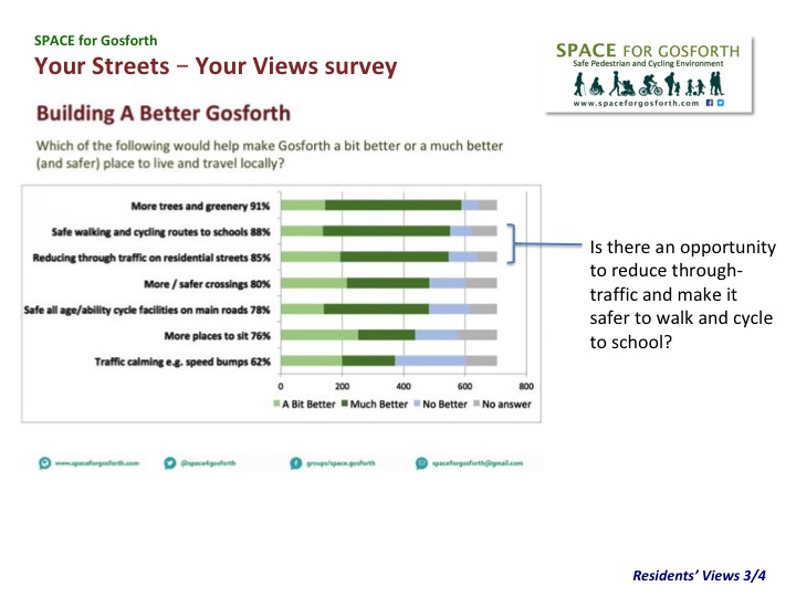
We also have data from the SPACE for Gosforth Your Streets – Your Views survey, which gives an indication of what people will support and shows that reducing through traffic and safe walking and cycling routes to schools could be popular.
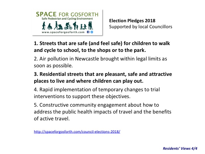
Separately, we know local Councillors support similar aims, below from the 2018 local Council elections. These include the option to trial interventions.
Bringing these together we can come up with some objectives for this proposal before even looking at what measures might be implemented.
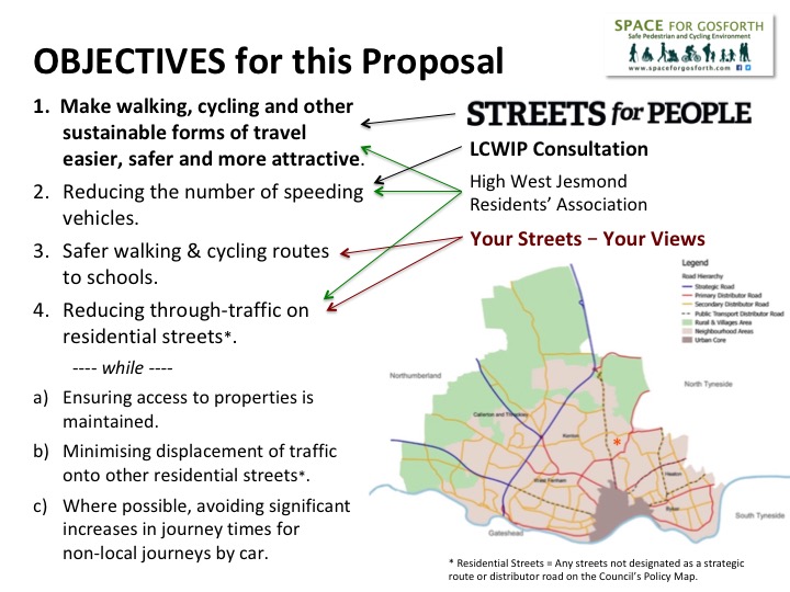
So, for this proposal we are aiming to meet the Streets for People objectives, reduce speeding traffic, make it safer to walk and cycle to schools and reduce traffic on residential streets.
We have also noted concerns about displacing traffic on to other residential streets and longer journey times by car.
By residential streets we mean streets that enable access to people’s homes but aren’t designated for through traffic. In the map above red lines show the routes of ‘primary distributor’ roads for through traffic including Jesmond Dene Road and Haddricks Mill Road. Orange lines show ‘secondary distributor’ roads including Gosforth High Street, Church Road and Station Road. These define the boundary of the area we are looking at, which goes beyond the current scope of Jesmond Streets for People but needs considering as one.
None of Moorfield, Moor Road North or South, Ilford Road or The Grove are designated for through traffic but all carry relatively high volumes of vehicles, many of which are currently using those streets as if they are main roads.
Analysis
Looking at a map of this area, it is noticeable how the area is already split by the Metro line and an east-west line including The Valley and the grounds of South Gosforth First School. Travel between these areas is limited to one or two options whether you are walking, cycling or driving.
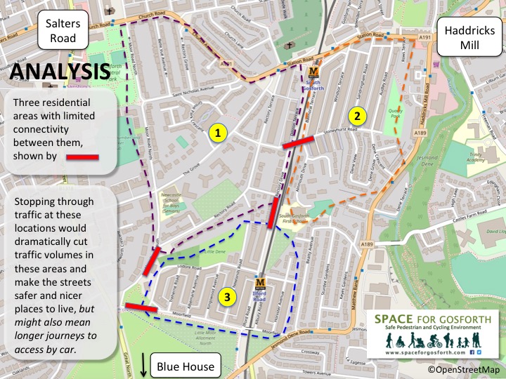
To help with the analysis we have split the area into three sub-areas each with limited connectivity to the other. So, High West Jesmond forms one of these areas connecting north via either Moor Road South or Ilford Road.
We haven’t included areas west of Moor Road or The Admirals (Beatty Avenue, Sturdee Gardens, Keyes Gardens) as these are already quiet streets with little through traffic.

For each of these areas we have used Google Maps directions to determine how long it would take to travel to Blue House, Haddricks Mill and to the High Street / Salters Road junction, and what options there are for routes. All journeys to or from the area by car would have to go through one of these junctions.
For example, Google Maps gives three different options for travelling from High West Jesmond to Haddricks Mill. One via Moor Road South / The Grove, one via Ilford Road and a third via Haddricks Mill Road. At 8.30am on a Monday morning the Haddricks Mill Road route is the quickest. We have used 8.30am on a Monday so that we take account of peak traffic on main roads and as this is also when children are travelling to school.

Travelling from High West Jesmond to Gosforth High Street, two routes are equally quick by car. One via Gosforth High Street and the other via Moor Road North. Of these it would be preferable to route traffic via Gosforth High Street which is designated for through traffic rather than Moor Road North which is a residential street.

In the other direction, the quickest route calculated at 5pm on a Monday afternoon is via Blue House roundabout.

Using these calculations and a few others not shown, we can determine the quickest vehicle routes to and from High West Jesmond. These do not require the use of Ilford Road and only use Moor Road South in a northerly direction.

The map belows shows what happens when the same analysis is repeated for the areas marked out by purple and orange dashed lines. From the purple area the quickest car journeys are via Church Road/Church Avenue/Station Road to the High Street and Haddricks Mill, and to Blue House via The Grove. The orange area is the same except that the quickest journey to Blue House is via Haddricks Mill Road.

Having completed this analysis we can draw some conclusions.
- If Ilford Road south of Rectory Avenue and Stoneyhurst Road at the Metro bridge were closed to vehicle traffic it would make no real difference to journey times by car. Some people who previously used those routes but change to using quicker routes may see their journey time reduce.
- If the southern end of Moor Road South was made northbound-only that also would make no difference to journey times.

Continuing the analysis, making the southern end of Moor Road North south-bound only where it meets The Grove would stop north-bound traffic using Moor Road North as an alternative to the High Street, again without impacting journey times. Residents returning to St Nicholas Avenue, Belle Vue Avenue and Rectory Grove from Blue House can travel via the Grove / Church Avenue.
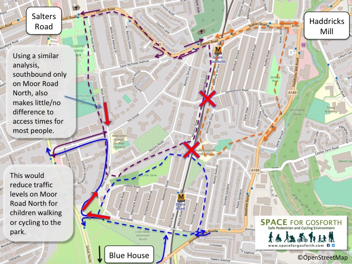
Making these changes would dramatically reduce the amount of traffic on the estate while making very little difference to journey times by car for residents. The one exception would be The Grove but this could be closed to through traffic between Grove Park Crescent and Stoneyhurst Road West. In this case residents of St Nicholas Avenue, Belle Vue Avenue and Rectory Grove would use Grove Park Crescent to access their properties. Although this would displace some traffic to Grove Park Crescent it is likely to be fairly small.
Reducing through traffic also makes the roads safer and more pleasant for walking and cycling, and safer for children travelling to local schools.

Proposal
Clearly any analysis like this won’t capture every consideration, but that doesn’t mean it isn’t worth trying. We would also like your feedback, as described at the end of this blog, to help us refine and improve this proposal if possible.
Our draft proposal submitted to Streets for People was to use temporary measures to stop through traffic on Ilford Road, make the south end of Moor Road North one way going south, and the south end of Moor Road South one way going north. These could be made permanent if the trial is successful. The remainder of Moor Road North and South would still have two-way traffic.
We would also propose stopping through traffic at the Stoneyhurst Road Metro bridge on a similar basis along with a “school street” on Alnmouth Drive to further improve safety for children travelling to and from school.
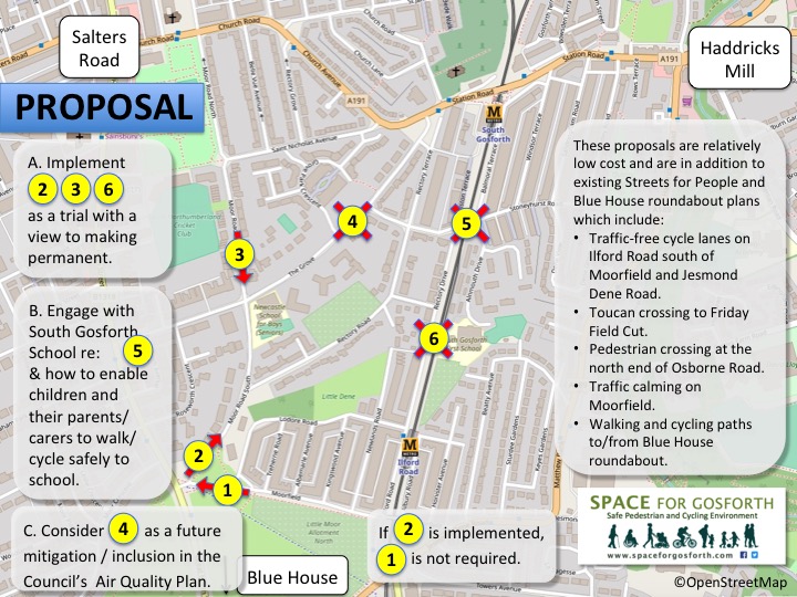
Possibly some of the traffic that was using residential streets might re-route via the local main road network, but given closing Killingworth Road didn’t lead to an increase in traffic on The Great North Road nor Benton Lane, the impact is likely to be minimal.
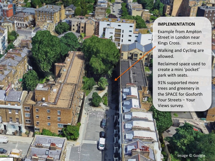
While any initial implementation is likely to use temporary materials to confirm the approach works, longer term we hope the closures might be used to introduce more greenery. A good example of how this has been done is at Ampton Street nor far from Kings Cross Station, where part of the road has been replaced by gardens with planting and seats.
Evaluation and Feedback
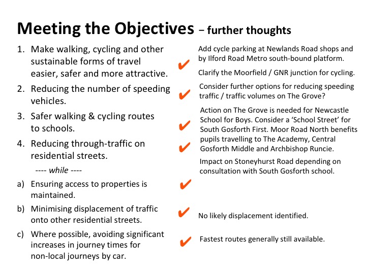
Looking back at the objectives, we think this proposal would do what we set out to achieve. With less traffic, local streets become quieter and more liveable and better for walking and cycling. A similar scheme at Waltham Forest resulted in increased levels of walking and cycling, and is expected to lead to substantial health benefits for those living in the area.
That’s our view but we would like to hear your feedback as well. Specifically:
- If you live in the area, would the proposal make it easier or harder for you to travel or encourage you to travel differently?
- If harder please do give us details of the journey that might be worse. E.g. starting street or area and approximate destination and how and when you travel.
- Any other related concerns not met by the proposal.

This is all irrelevant because the council have given planning permission to build 8000 houses just north of Gosforth – they are currently widening the roads for easier access and extra traffic – which is all going via Gosforth
If you happen to live between 2 proposed road closures as I do (Rectory Drive ) between 5 & 6 on map it would mean car access to my house nigh on impossible without a considerable diversion around & having to get on to busy main roads.
I support safer streets & cycle to work on a daily basis but have some need to use car on a very regular basis- eg family members with limited mobility, urgent work call in etc
Hi Heather,
Thanks for the comment. Just in case it is not clear, (5) refers to the east-west crossing over the Metro line so access wouldn’t be too restricted.
I’ve checked using the same method as the analysis in the article looking at journeys from Rectory Drive about half way between Rectory Avenue and Stoneyhurst Road. For trips via Salters Road and Haddricks Mill there doesn’t look to be any difference in time. Getting on the main road should not be a problem because access would be via the traffic lights at the north end of the Grove. For trips via Blue House it might add maximum a minute or so.
I’m happy to check further options / times if you can give more details.
I agree with road restrictions, less traffic, safer journeys to schools and think the pictures of the streets near Kings Cross are brilliant. My worry is that you are pushing more traffic onto ‘secondary distributor’ roads including Gosforth High Street, Church Road and Station Road as a way to deflect the problem. You state that these roads might be designed for more through traffic, however a large number of people still live on them. They have drives, gates and windows and doors opening onto these increasingly busy roads. The same goes for the cycle lanes painted outside peoples houses on the GNR. If they were painted up and down Treherne Road, The Drive or Oakfield Road for example would the cyclists complain of people parking in them there? We need a balance and to create an environment and road layout in Gosforth that encourages people to walk, drive slowly and use the High Street for shopping. Would you drive into Central London to go to the shops? As Stewart Falconer rightly says, NCC are allowing thousands of new homes north of Gosforth with no infrastructure in place. We need to make using a car around Gosforth a less attractive option to change peoples habits. I think the changes described above are a move in the right direction. But in order to not displace traffic, please can we look holistically at Gosforth, including the West side and up Salters Road?
My main concern is that the Council is likely to be short of cash as a result of the COVID19 emergency for any substantial hard engineered schemes. One possible solution is that used in Belgium, where the blue painted cycle lanes are placed in the centre of the road. Motor vehicles cannot overlake cyclists, and of course there are very clear road signs to indicate this on entry to the affected streets.
This has several advantages
1. It is relatively cheap, as costs are limited to road signs and markings
2. There is no loss of road space for motorists, who often become frustrated by costly schemes that have low take-up by cyclists
3. If cyclists are present the traffic speeds are automatically calmed to 15 to 20 mph
This type of scheme could easily be introduced on a trial basis on Moorfield, Iford Road and Moor Road, which are all part of the Council’s strategic cycle network. Consultation with local residents would be essential in advance of a trial.
Hi Roy, I’ve not seen the blue lanes you mention but the suggestions in this blog could be achieved with just a few planters, or even a concrete block, so aren’t exactly expensive. If you have a link I would be interested in seeing what the blue lanes are.
The Dutch have a similar concept of cycle streets, but these were only successful when the Dutch also removed through traffic. i.e. they would be in addition to our proposal rather than instead of. There’s more about this here:
https://bicycledutch.wordpress.com/2015/04/07/another-new-bicycle-street-in-utrecht/
Yes, it was the ‘fietsstraat’ that the Dutch and Belgians use that I was thinking about. They are definitely not as good as properly engineered solutions and only work if the signs for motorists explaining the changed priorities are dominant and repeated regularly along the route. There are a few good examples, including some with an extra 1.5 m white line next to parked cars to reduce the risk of “dooring” cyclists, by encouraging riders to occupy the centre of the road lane.