
SPACE for Gosforth recently responded to Newcastle City Council’s Bus Service Improvement Plan consultation covering proposals in Gosforth, Byker and the West End. This blog is SPACE for Gosforth’s response.
You can see full-size diagrams of the proposals and an explanation of the Bus Service Improvement Plan on Newcastle City Council’s website.
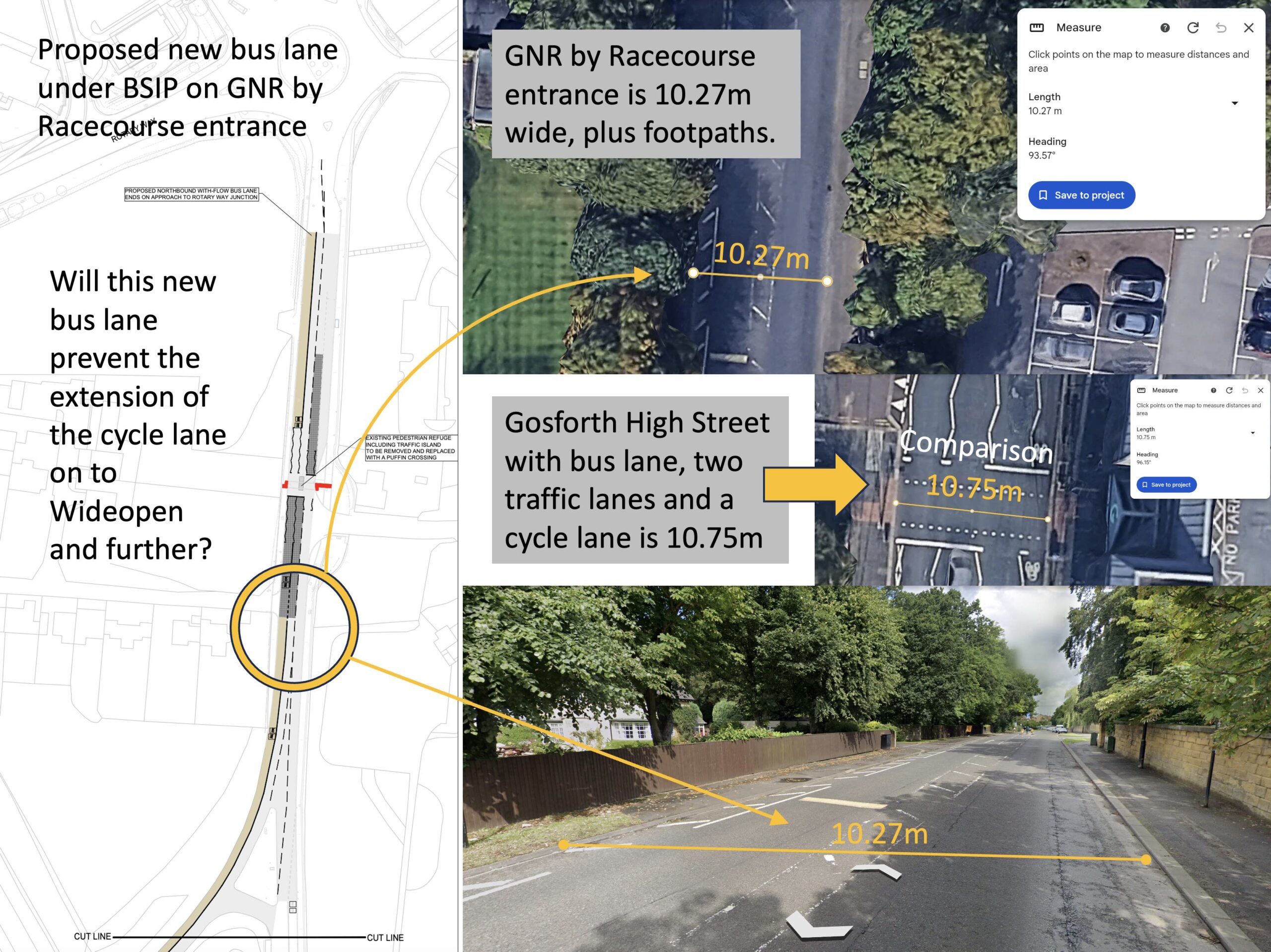
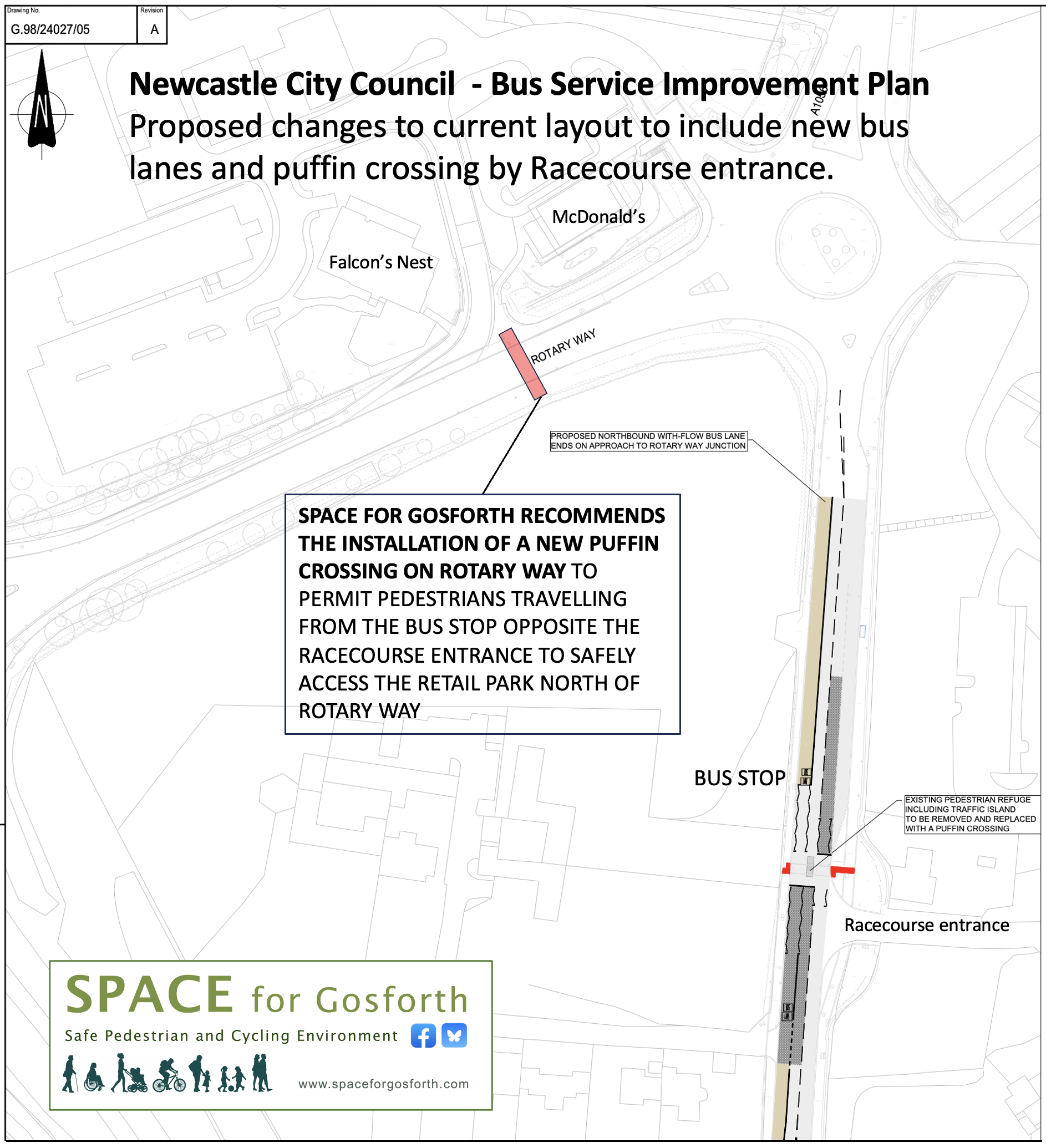
GNR corridor – New bus lane over the flyover to the racecourse and up to the Rotary Way roundabout
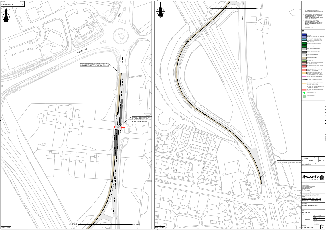
Proposed north-bound bus lane on Rotary Way
- We understand that this bus lane is designed to alleviate the current situation where buses are caught in traffic queues at peak times from the Rotary Way roundabout back to the flyover over the GNR.
- We are very concerned that the proposed bus lane could prevent the continuation of the GNR cycle path that currently ends at Brunton Lane, up to Wideopen and ultimately Cramlington. (Please see attached images) This cycle route is critical as there are no nearby safe alternative routes for people in Wideopen to cycle to Gosforth or vice versa, or to use the facilities at Newcastle Racecourse. This would include children attending Gosforth Academy, or Great Park Academy. Even if the proposed bus lane doesn’t prevent a cycle route, implementing the scheme as is would be costly compared to if the cycleway and bus lane were implemented in one go e.g. the puffin crossing would be correctly placed rather than installing it then later having to move it.
- This cycle route (from Brunton Lane to Wideopen) is shown both on the Newcastle LCWIP https://democracy.newcastle.gov.uk/documents/s172250/Annex%20C%20LCWIP.pdf and the North Tyneside LCWIP https://my.northtyneside.gov.uk/sites/default/files/web-page-related-files/NT%20Cycling%20Strategy%20inc%20LCWIP_Final.pdf
- A reconfiguration of the Rotary Way roundabout with actuated traffic signals could prioritise traffic that currently delays northbound buses at peak times without having to install a bus lane thus allowing space for the cycle path to be extended north. Cycle crossings could be included in the design that would ultimately allow cyclists to cross over the roundabout to a new cycleway to be constructed at some point on the headland of the field to the west of the A1056 from Rotary Way to the Wideopen junction.
- The new east-west Puffin crossing located by the entrance to the racecourse will be of great assistance to pedestrians/bus passengers who need to cross the busy road here. People cycling should also be able to use this crossing to access the proposed and existing services by the roundabout.
- We believe that a further north-south Puffin or Toucan crossing, connecting the bus stop to the retail/fast food/pub area to the north of Rotary Way, is required for pedestrians/bus passengers. Many of the employees of these businesses arrive by bus and currently have to cross a four-lane road. Many of the customers of the same businesses are people who don’t have access to a car or who don’t drive. We are aware that it is not uncommon for youths to play football for a few hours at Goals, or play mini golf, at the racecourse site, and then walk to McDonald’s or Mimi’s ice cream parlour for refreshments afterwards. Currently they are forced to cross multi-lane roads at a busy intersection. It is essential that travel planning includes those who don’t drive.
GNR corridor – New north-bound bus lane south of Blue House roundabout
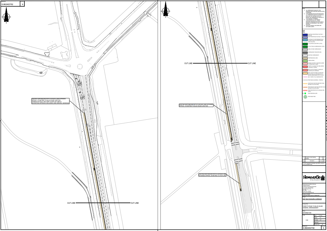
Proposed north-bound bus lane south of Blue House roundabout
- We support this proposal as it prioritises buses without putting other road users at risk.
The Council should consider whether the speed limit on this section of road should be reduced further in light of the death of 40 year-old pedestrian Andrew Murphy in March 2024. https://www.chroniclelive.co.uk/news/north-east-news/police-name-man-killed-great-28908278 - Thirty five people have been injured at Blue House junction since 2018 since the Blue House working group proposals were published. The Council should therefore also consider if some of the safety improvements proposed by the Blue House working group could be implemented at the same time including pedestrian/cycle crossings at Blue House roundabout, and updating the layout as set out in drawing A from the working group proposals. https://highwestjesmond.co.uk/meeting-hears-recommendations-blue-house-working-group/
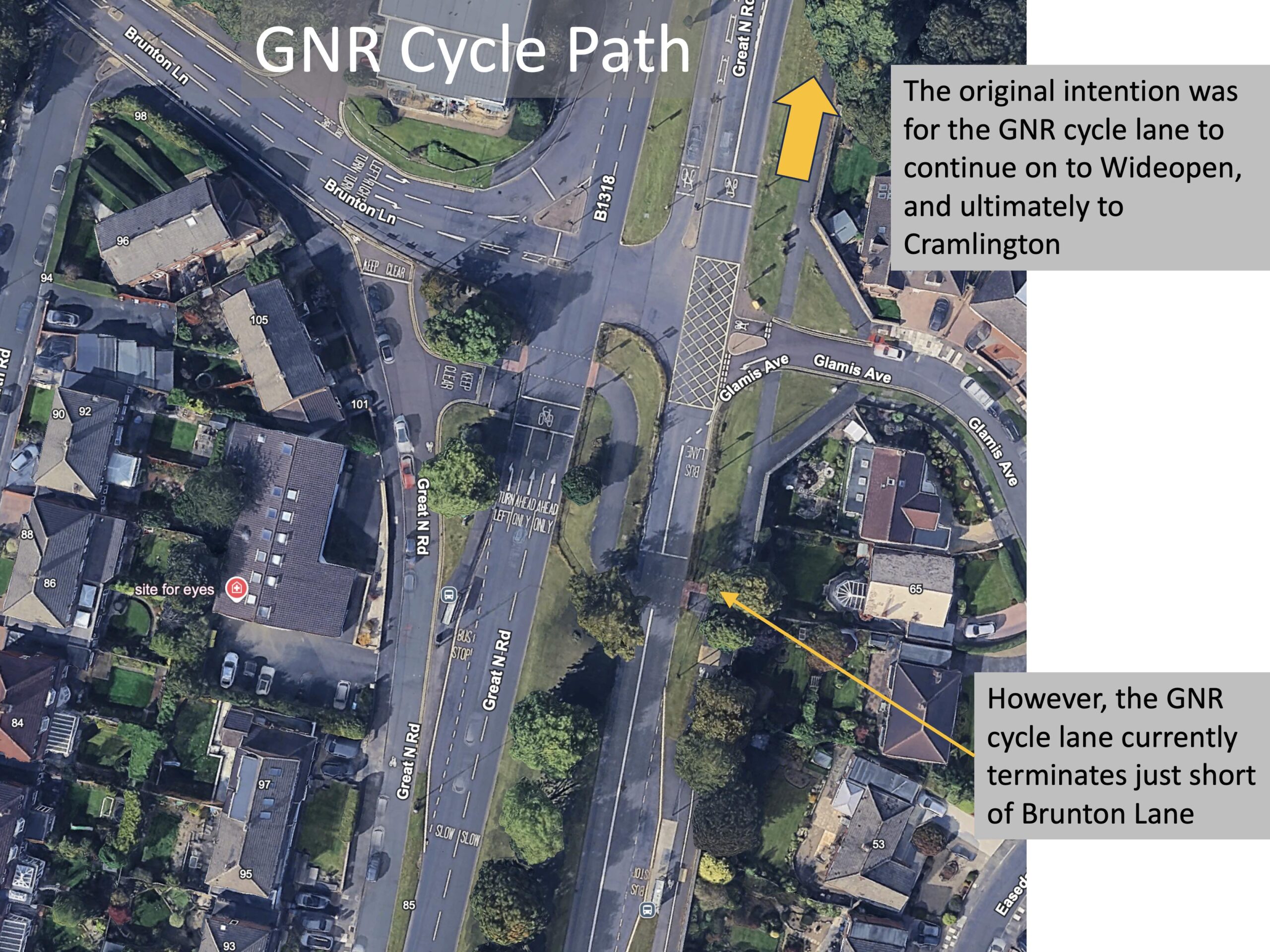
The north end of the current Great North Road cycle lane.
Will the proposed bus lane prevent the Great North Road cycle lane from being completed?
The three proposals below all include routes or destinations that we would like to be able to access by bike if possible, as (if safe routes exist) this would be quicker, cheaper and more convenient than having to take one bus into the city centre and another back out again.
Wallsend corridor, including Shields Road and New Bridge Street, east of Central Motorway
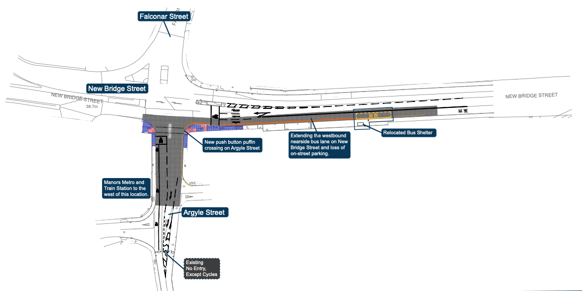
Proposed bus lane on New Bridge Street
- It is not clear where the main cycle route is from the city centre to Byker is, but this needs to be defined and road-space allocated prior to committing to new bus lanes. This cycle route needs to be usable after dark, as well as during the day, which currently rules out the route via City Stadium.
- It would be beneficial if, as part of this proposal, north-south movement between Falconer and Argyle Street could be made safer by bike. This could include narrowing the junctions and removing the slip road entrance to Falconer Street from the west.
- Access could also be improved by bike to and from Manors Metro and mainline railway stations. Anyone travelling from the east into the city centre on Metro with a bicycle has to get off at Manors Metro and continue their journey by bike, so there needs to be a safe link into the wider cycle network at this point. With the reopening of the Northumberland Line, Manors Railway Station is a potentially a preferable alternative to Central Station for residents living in the east and north of the city, who are travelling to the railway by foot or by bike and are travelling north on the Morpeth or Northumberland Lines. There is therefore a need to improve access to Manors Railway Station to ensure that Newcastle residents can benefit from the increase in rail services in same way that Northumberland residents are able to do so. It should also be borne in mind that workplaces such as Cobalt business park are much easier to commute to via rail and folding bicycle due to the new rail services.
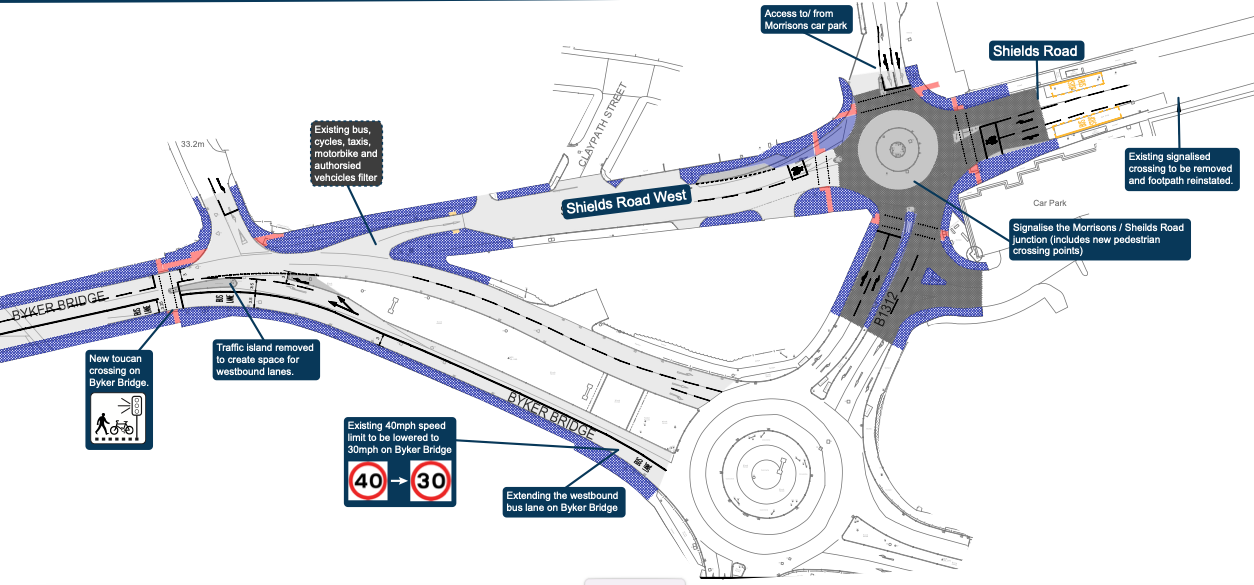
Proposed changes to Shields Road
- Please can you look at making the proposed new crossing south of the Byker Morrison’s roundabout usable by bike to link up Shields Road west and the car park south east of the junction (Clifford Street) as a way of linking City Stadium and Byker Link cycle routes. Signing this route would assist cyclists who are not familiar with the route especially as the Byker Link is an access route for tourists using Hadrian’s Way to access local services in Shields Road and the surrounding neighbourhoods.
- Consideration needs to be made as to whether Shields Road West is suitable as a short cut for buses and taxis (or all vehicles between 7pm and 7am) given the need for a safe connection for people cycling.
- Shields Road is a major local destination (comprising multiple individual shops and services) and it should be possible to access and travel safely between these shops and services by bike. These include two cycle shops (Edinburgh and Cycle Centre) as well as the East End Pool, especially as the East End Pool is also used for outreach services such as children’s vaccinations. The new junction layout by Morrisons at the west end of Shields Road should facilitate this access and be future-proofed to take account of future plans to improve cycling on Shields Road.
- The speed limit on Shields Road should be 20mph to improve safety and encourage through traffic to use the bypass route.
Central Motorway and Stamfordham Road corridor
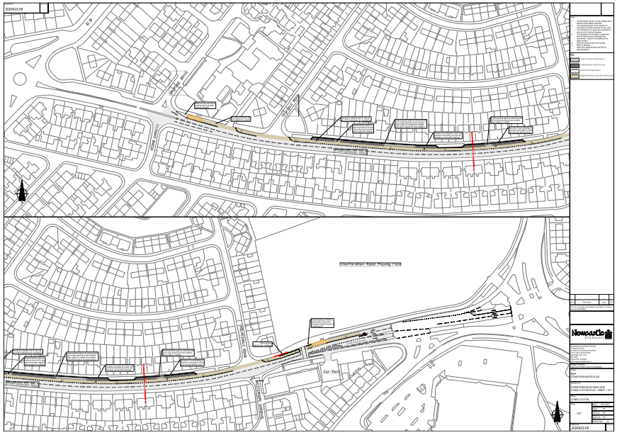
Proposed bus lane on Stamfordham Road
- There needs to be defined (and safe) cycle route either on Stamfordham Road or on a parallel road. This would be a good use of BSIP funds to prevent buses from being held up by people cycling slowly uphill in the bus lane.
- The proposal should address existing pavement parking issues on the south side of Stamfordham Road as currently accessing bus stops on the south side may not be possible with a pushchair or wheelchair.
- The crossing from Druridge Drive to Acomb Gardens could be improved for cycling so it is a more direct crossing. This is a useful link from Kenton area to Bavington Drive and then onto the north end of Denton Dene.
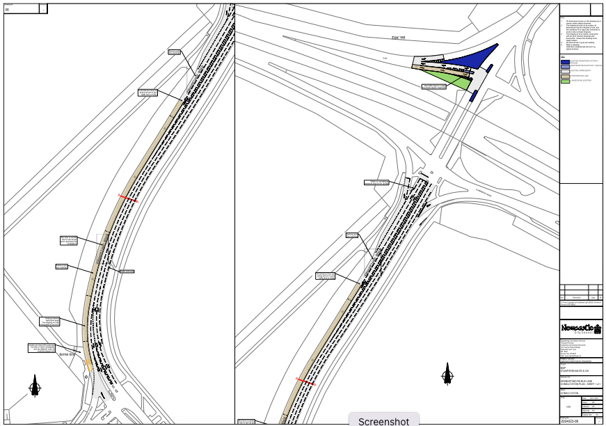
Proposed bus lane on Grandstand Road, south of Central Motorway
- On Grandstand Road connectivity across the CME bridge needs to be improved for cycling so the ‘cyclists dismount’ sign (possibly the only one in the city?) can be removed. The cycle route needs to be continued along Grandstand Road to Gosforth as there are no other direct links between Fenham and Gosforth by bike. This would enable school children, who are currently driven between Gosforth and Fenham and vice versa to travel by bike instead of by car. It should be noted that two Gosforth Primary Schools (St Charles and St Oswalds) are feeder primary schools for St Cuthbert’s and Sacred Heart Secondary Schools, and that other children travel from Gosforth to Dame Allan’s Private Schools. These are all journeys that are potentially replaceable by walking or cycling, but the access routes between the two suburbs needs to be safe for child cycling. This is particularly important due to the lack of bus services linking Fenham and Gosforth.
- Pending the installation of a safe cycle route between the CME and Gosforth along Grandstand Road, the Council should reduce the speed limit to 30mph or less for safety reasons.
- There are major accessibility issues due to the design of the gates at both locations where the cycle route joins the Town Moor from Grandstand Road south of the CME, as it is not possible to enter or exit the moor with a non-standard cycle and even with a standard build cycle. The City Council was recently sued regarding a barrier on Hadrian’s Way, resulting in the removal of that barrier. Similar priority should be given to removing these inaccessible barriers and other similar barriers to accessing Town Moor paths. Our understanding based on similar cases elsewhere is that it would be very difficult to successfully defend such a legal action, and we are concerned that public money and officer time could be wasted should further legal proceedings of this nature be instituted. This is particularly concerning at the present moment, when Newcastle Council has been very clear for a number of years that it has insufficient funds.
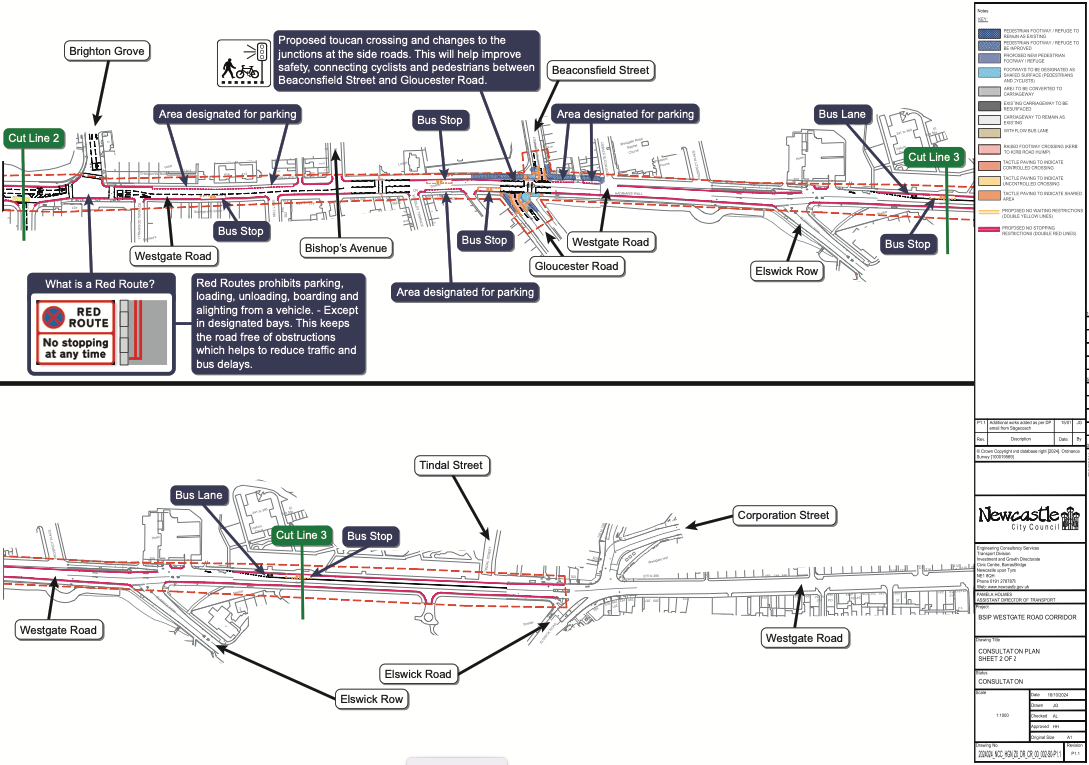
Westgate Road corridor
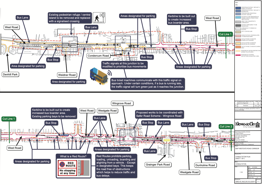
Proposed changes to West Road 1 of 2
Proposed changes to West Road 2 of 2
- Westgate Road / West Road is also major local destination (comprising multiple individual shops and services) and it should also be possible to access and travel between these shops and services by bike. According to the Council’s adopted transport hierarchy, and to ensure safety of all road users, this should take precedence over parking and public transport.
- We also note the Council has adopted LTN1/20 but none of these proposals comply with that standard. LTN1/20 should apply to all the Council’s transport schemes just as we would expect all roads in the city to comply with standards that apply for vehicles and have a functional pavement. This should be regardless of whether the scheme is badged as being a ‘cycling’ scheme or something else, unless (like on the Central Motorway) it is a road where cycling is banned.
- If not already 20mph, the speed limit through the shops should be set to be 20mph.
- Consideration should be given to how to enable north-south crossings by bike to reduce the risk of severance due to heavy traffic. This is particularly important to allow access to the many schools in the area (including St Cuthbert’s Secondary School, which – as previously stated – is a feeder secondary for St Charles’ and St Oswald’s Primary Schools in Gosforth) and also to the Elswick Road / Benwell Lane cycle routes and to Hadrian’s Way.
A couple of associated comments.
The speed limit on Grandstand Road on the approach to Blue House Corner must be reduced to at least 30mph. The sightline on this approach is dangerously compromised by the Blue House and speeding cars don’t have time to assess traffic coming from Gosforth. I have had experience of being nearly smashed into by such a vehicle.
The pavement at the bus stop at Moorfield is a cycle route but there is nothing to warn bus passengers waiting in the shelter of this. More than once I have stepped out from the shelter to be nearly crashed into by cyclists whizzing down that section towards Gosforth. Both cyclists and bus passengers need protection at this bus stop. A clear panel in the shelter would at least give passengers a view of approaching bikes and cyclists a view of them and their movements. Signage would also be welcome.
Finally as a resident of Moor Road I am concerned about the possible closure of the route on to the GNR via Moorfield. I appreciate there is a problem with rat-running in this area but there are other alternatives to simply closing the road. Traffic calming measures on Moor Road would be most welcome and be less problematic for residents in this area who use this access route.
Thank you for your work on our behalf.