 Junction improvements in the west of the city – have your say! By 6 October 2019.
The Council are consulting on changes to seven junctions in the west of the city. All of these junctions are within about three miles, or a fifteen minutes cycle ride from Gosforth High Street.
The Council say that these junctions have been identified as “problem junctions that need investment to improve efficiency and journey time reliability, as well as provide greener and more active travel choices and improving road safety.”
Have your say on the Council’s Commonplace website until 6 October 2019.
This text, as well as the junction designs, suggest that ‘efficiency’ and journey time reliability are the key priorities for the Council. By efficiency we believe the Council means more cars rather than more people. If the latter we would expect bus priority to be designed in whereas none of the junctions have this.
We might also expect good quality walking and cycling routes as walking and cycling are both very efficient in terms of energy use and space required, and travel times are far more predictable than driving. For local journeys, cycling is frequently quicker than driving too.
More surprisingly is that the Council are proposing junctions that will increase vehicle usage when it was only five months ago in April 2019 when the Council declared a Climate Emergency. The Council has a target to reduce transport emissions by 16.5 kilotons CO2. Designing big junctions that add emissions will just make that target harder to meet.
Back to the Drawing Board (again)
The council has been urged to 'go back to the drawing board' https://t.co/pG1eNpXz4d
— The Chronicle (@ChronicleLive) March 14, 2019
So just like for Haddricks Mill, we are urging the Council to go back to the drawing board. Junction designs need updating to ensure they move people efficiently and safely rather than solely focusing on vehicles.
As these are major schemes, we are also asking the Council to update their consultation material so that:
- Rather than expecting people to work out what changes are proposed, this is explained e.g. addition of new lanes, traffic lights or crossings.
- The impact (increase or decrease) in vehicle capacity is made explicit.
- The impact on green house gas emissions is provided for 3-5 years in the future by which time vehicle numbers will have increased to fully use up the new capacity.
- Questions relating to congestion are removed from the survey, as the changes proposed are unlikely to make any difference to congestion. Road pricing is the only effective way to achieve a significant and lasting reduction in congestion.
- Example walking and cycling routes through the junction are explicitly shown on the plans. (We couldn’t tell from some of the plans what routes were proposed.)
- Relevant Council policies are listed (including climate change and air pollution) and how the proposals will support achievement of those policies.
This will allow the public to take an informed view, and to judge the practical impact of the proposals.
Planning Policies
The consultation also suggests that the ‘problems’ with these junctions has been created by new housing developments in the west of the city.
In the Council’s Development and Allocations Plan policy document the first paragraph under Transport and Accessibility is:
“National policy promotes sustainable development which minimises trip generation and journey length, encourages the use of sustainable modes of transport and promotes accessibility for all. Sustainable development also helps reduce the need for people to travel, manages congestion, improves road safety, meets climate change reduction targets, as well as improving people’s health by creating more opportunities for walking and cycling.”
If these new developments have lead to such substantial increases in traffic that seven separate junctions are impacted and need to be completely re-designed, then feedback needs to be provided to the Council Planning department that their planning process has failed and urgent remediation is required.
The Junction Proposals
Two of the junctions are fairly simple T-junctions, the other five are large cross-roads. We have looked for equivalent junctions in the Netherlands to see what might be possible and so you can compare yourself.
Where the junctions increase vehicle capacity, which appears to be the case in all of the proposals, this will most likely lead to more driving and increased green house gas emissions. As we have said, Newcastle CIty Council needs to explain how this is consistent with declaring a climate emergency, and how it will impact their targets to substantially reduce green house gas emissions.
It’s also worth noting given the frequent use of shared space that, as at Haddricks Mill, this is not likely to be effective in encouraging more people to cycle. Protected cycle lanes are much more effective, as well as being widely supported (78% supported safe all age and ability cycle lanes in the SPACE for Gosforth Your-Streets Your-Views survey).
A. A Dutch T-junction
Our first example is from Ijmuiden close to where the ferry from South Shields docks. If you take bikes on the ferry it’s actually the route from the ferry port to the beach. Both roads have two-way cycle lanes, and the cycle lane on the main road continues in a straight line and has priority over the side road. There are no traffic lights or right hand turn lanes.
There aren’t dedicated pavements at these locations because there are very few people walking, but you can walk along the cycle tracks just as you would walk on the road in the UK countryside.
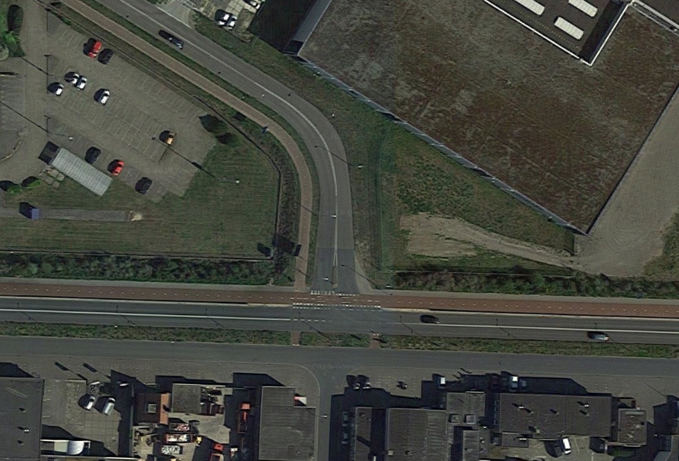
Junction of Kromhoutstraat and Strandweg in Ijmuiden, Netherlands
B. A Large Dutch Intersection
This example is from Utrecht. It’s actually quite hard to find a junction like this in the Netherlands as many roads this size have underpasses so people can walk or cycle straight through without having to cross the traffic.
It does however show quite clearly the cycle routes (in red). The beige next to the cycle routes is the pavement. The cycle routes are quite wide as they are 2-way on both sides of the roads because the road itself is so large.
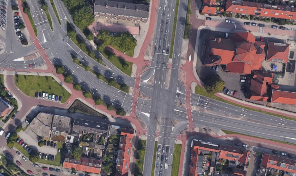
Junction of Vleutenseweg and Spinozaweg in Utrecht, Netherlands
This is the Google Streetview for the same junction. The routes are coherent, direct, safe, comfortable and attractive, which, according to the UK Government’s Local Cycling and Walking Infrastructure Guidance, is how local authorities in the UK should be designing road junctions with cycle provision.
The following are the Council’s proposals, proceeded by Google StreetView of the current junction.
1. Brunton Road/Brunton Lane
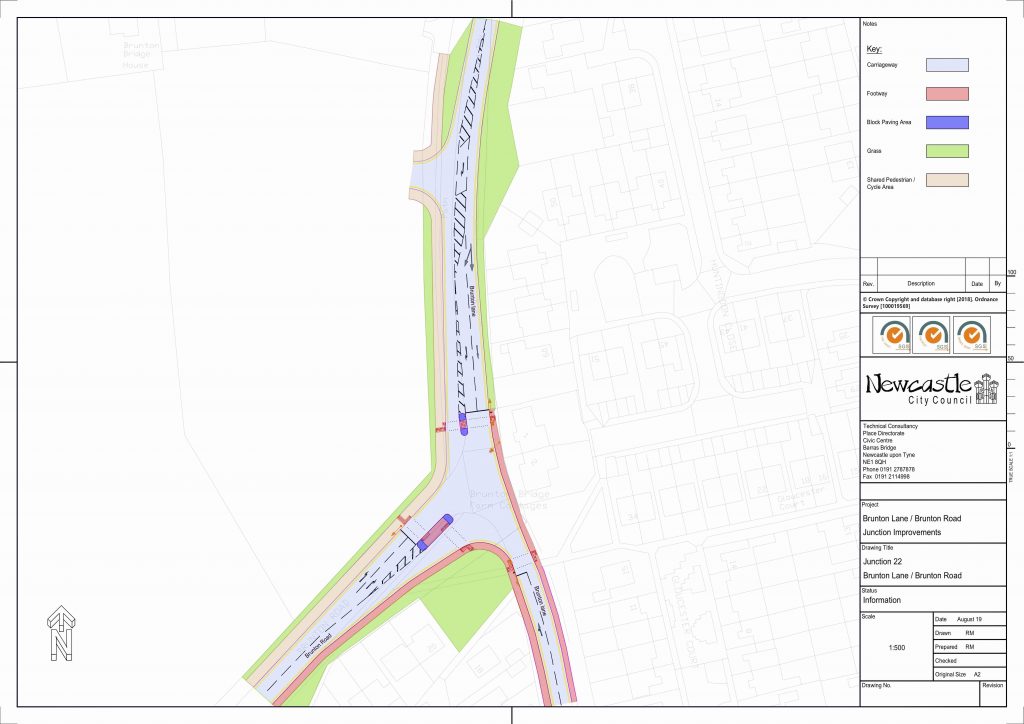
The new proposals do include new (shared) pavement and pedestrian crossings, but most of the additional roadspace is to increase the vehicle through-put of the junction. Cycle lanes are shared, and at the junction to the north are interrupted by an entrance to a side road.
2. Ponteland Road/Station Road
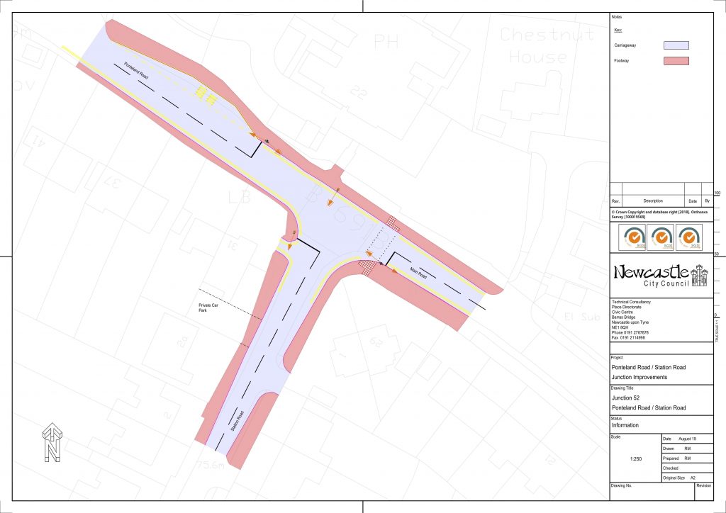
The new proposal is to add traffic lights to the junction, most likely to give more priority to traffic coming from the A696 to the south. This will increase traffic and make it more dangerous for people cycling, who have no dedicated facilities at this location.
3. Ponteland Road/Etal Lane

The addition of traffic lights at this junction will make it easier to cross these very busy roads. Having some separated space for cycling is also a small benefit but overall the experience for people walking or cycling at this junction will still be poor. Routes are incoherent and difficult to read jumping from shared space to separate space and back again, are indirect from both the size of the roundabout and the off-set crossings, safety is compromised for people cycling because the routes don’t connect, and overall it doesn’t look to either be comfortable or attractive.
4. Ponteland Road/Harehills Ave

At Harehills Avenue, again there is an incoherent mix of shared and separate walking and cycling routes. It doesn’t even look possible to travel SW to NE by cycle, even though that is probably one of the most likely uses of this junction by people cycling. Neither Harehills Avenue (NE) nor Blakelaw Road (SW) are marked as roads for through traffic on the Council’s policy map so it is not clear to us why these roads require multiple exit lanes or two stage crossings.
5. Ponteland Road/Springfield Road
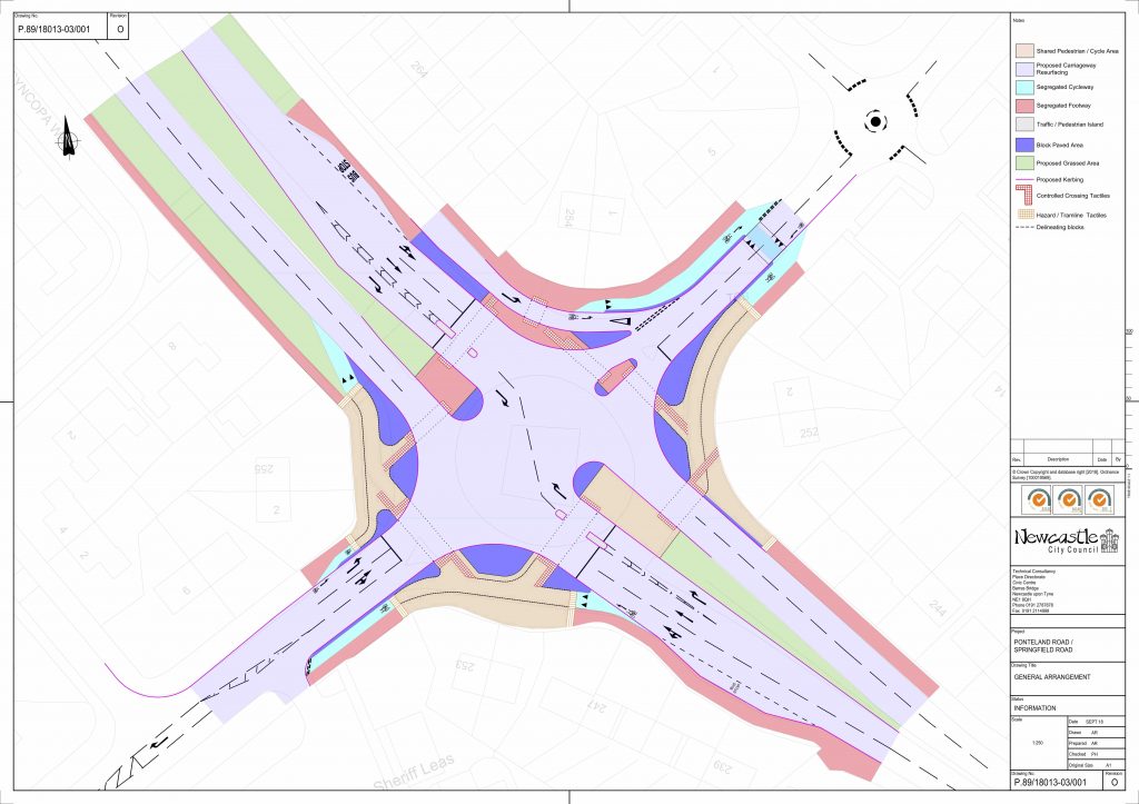
This is very similar to the Harehills junction and suffers from most of the same issues, including the lack of a cycle route from the SW to the NE. There is also plenty of space on Springfield Road for separate protected cycle lanes with minimal adjustment to the current road, if people parking are asked to park on the road rather than the pavement as now.
6. Stamfordham Road/Pooley Road
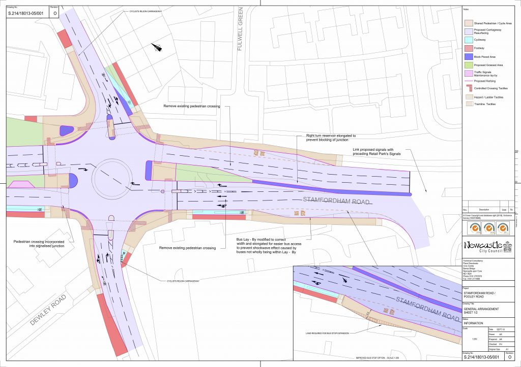
Coming from the east, the cycle way on the south of the road currently almost reaches the junction so it is not clear why this has been removed. Additional crossings on the west and north sides will be beneficial for people walking.
7. Stamfordham Road/Springfield Road
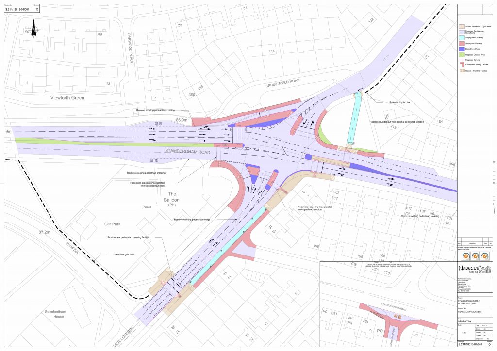
Again, like all the previous junctions, this junction appears to be designed for maximum vehicle throughput with walking and cycling as an add-on. This is a big area and it would certainly be possible to design something more like the Dutch junction we shared at the top of this blog if the Council chose to do so.
Comment by 6 October
You can have your say on the Council’s Commonplace website until 6 October 2019. Contact details for the Council Cabinet members responsible for Transport and for Climate change are available on the Newcastle City Council website.
You might want to consider mentioning:
- The need for better walking and cycling routes that are coherent, direct, safe, comfortable and attractive.
- The need for walking and cycling to be separate rather than shared space.
- More traffic also means more pollution and more risk of injury for vulnerable road users.
- The Council’s commitment to reduce transport-related CO2 emissions.

