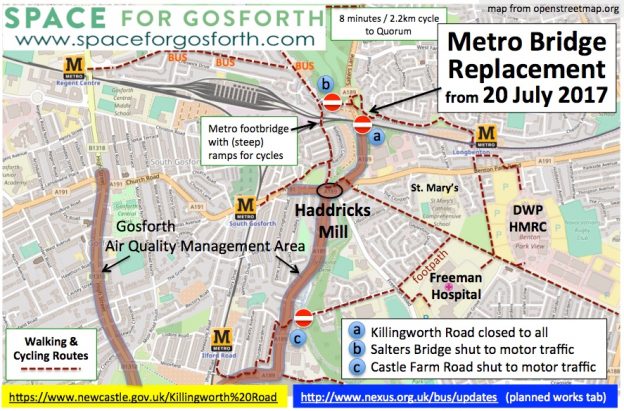

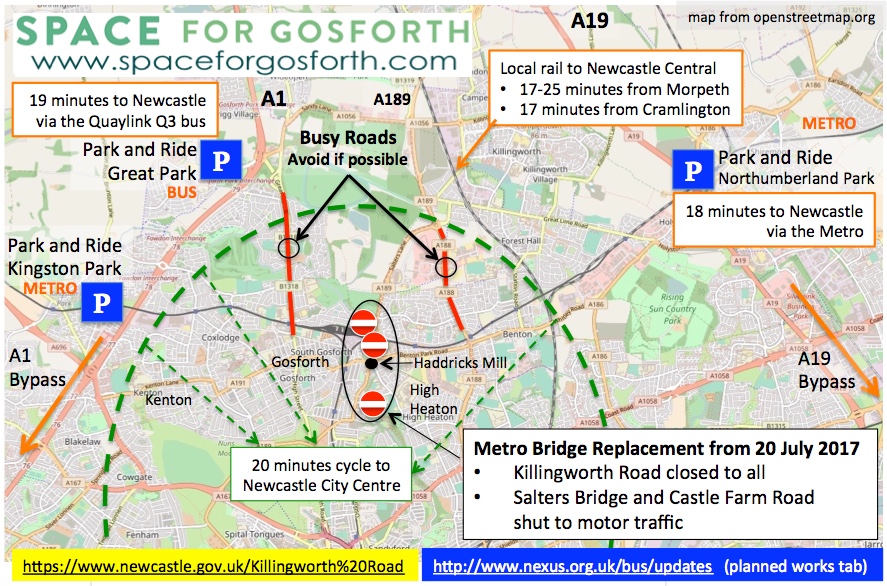
Newcastle City Council has announced the start of the works to replace the Killingworth Road Metro bridge and widen Killingworth Road. From 20 July 2017 for up to nine months, Killingworth Road will be shut to all traffic including people walking and cycling. Salters Bridge and Castle Farm Road will also be shut to motor traffic.
The Council have established a ‘Mitigation Board’ to plan for and manage the impact of the works. They tell us “We’ve got a lot of data about the impact of the closure of Killingworth Road on the network from all the monitoring we have done during the temporary closures so far. The Mitigation Board are confident that they have anticipated the issues and created an effective traffic management plan, having said that, there is always the potential for people to start behaving differently so we will continue to monitor flows and volumes and throughout the closure … the Mitigation Board will continue to meet and take action if issues arise that haven’t been anticipated.”
The key word here is ‘behaviour’. While some people will have little choice but to drive, many more can change when they travel, how they travel or even if they travel at all. In the British Social Attitudes Survey from 2013 “a third ( 33%) said that they could just as easily catch the bus for many of the journeys of less than two miles they now travelled by car, 37% said they could just as easily cycle (if they had a bike) and 40% of people agreed that they could just as easily walk“.
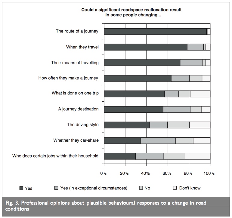
The table below is from the study Disappearing Traffic? The Story So Far that looked at over 70 examples of where roads had been closed, mostly planned but in a few cases as a result of natural disasters with no notice at all. The consistent conclusion was that traffic levels adjust to the new capacity and that “predictions of traffic problems are often unnecessarily alarmist“. As if to prove a point, this was the headline from the Chronicle’s coverage of the works in March: Killingworth Road roadworks LIVE: Updates as traffic chaos expected at major Newcastle junction.
That doesn’t mean to say that road closures / road works don’t need to be planned for. Good planning, and good communications, can significantly reduce the short term impact while people adjust to the new circumstances, especially where these short term impacts might put vulnerable road users, for example children walking to school, at greater risk. We’ve compiled a checklist below that we will also be sending to the Council’s Mitigation Board.
Mitigation Planning Checklist
1. Helping People Plan
|
2. Moving People, Goods and Services
|
3. Protecting Local Residents
|
4. Protecting Vulnerable Road Users
|
Planned Works
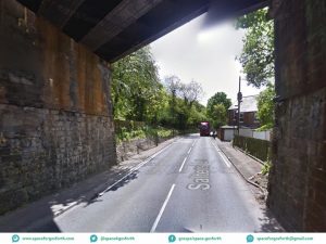
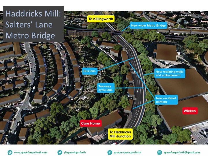
This is an important location for walking and cycling improvements. The current road (shown on the right) is both extremely unpleasant to use and is one of the few locations heading north out of the city where people walking and on bikes can cross the metro line on the level without having to use a bridge.
It’s worth noting that the air pollution measurements from by the care home in the picture below were, in 2015, the worst of any in the Gosforth Air Quality Management Area. Making it easier to walk and cycle, and allowing buses to bypass queuing traffic, should all help improve the air quality in this area, however this may be offset if separate plans for the Haddricks Mill junction increase vehicle capacity and induce additional traffic.
The changes to be carried out are those that were consulted on as part of the Blue House / Haddricks Mill proposals in the summer of 2016. While we haven’t seen final designs we believe they are largely unchanged from those originally presented i.e.
- Replacing and widening the Metro Bridge.
- Creating on-street parking spaces for residents living on Killingworth Road.
- Widening the pavement and removing the need for pedestrian railings.
- Creating a new south-bound bus lane and 2-way cycle track.
The original consultation and residents’ comments can still be seen on the CommonPlace consultation website. Planned changes to the Haddricks Mill junction are not in scope of this change and will be published separately.
Ecological Impact
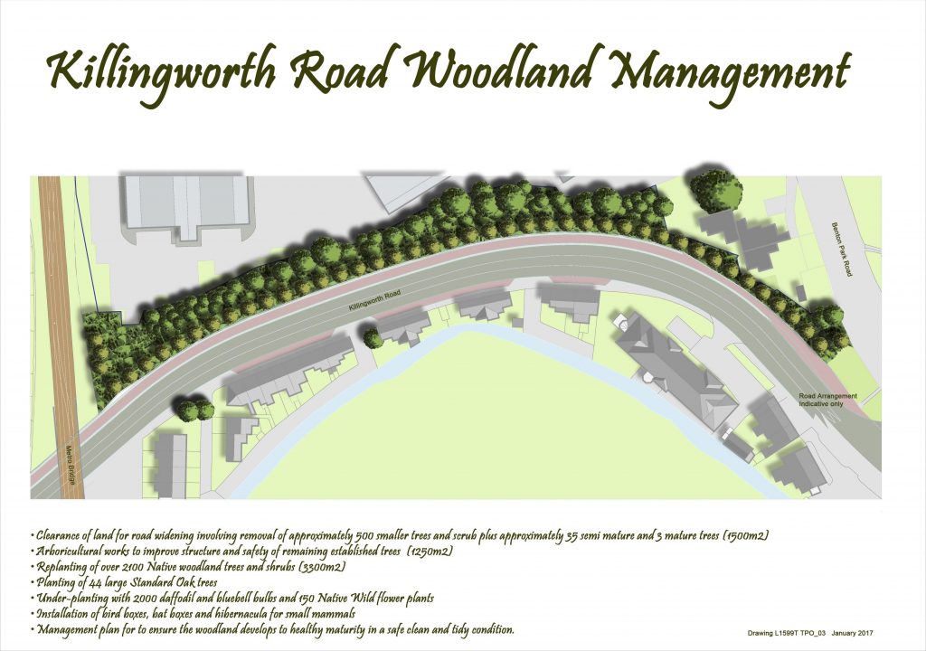
One further aspect of this scheme that deserves scrutiny is the impact on the wooded verge on the east side of the road. The associated planning application (reference 2017/0641/01/GRA) includes:
- Removal of 500 smaller trees plus 35 semi-mature and 3 mature trees to be replaced by 2100 native woodland trees and shrubs and 44 large standard oak trees.
- Planting 2000 daffodil and bluebell bulbs and 150 native wild flowers.
- Installation of bird boxes, bat boxes and hibernacula for smaller mammals.
- A management plan for the area.
Details of the full Ecological Impact Assessment and associated mitigation plans can be found on the Planning Applications website.
Longer term, helping people walk and cycle more will not only help reduce the devastating impact of air pollution on us, but also on plant and animal life.
Residents’ Letter
This is the letter that was sent to local residents by the Council.
 |
excellent information as usual.
I also understand that additional metros will be running to and from Regents Centre over the period the Metro Bridge is being replaced. Any hope of a temporary revised timetable from Nexus?
Finally bearing in mind its anticipated increased usage can it be confirmed and reiterated that the footbridge (stepped access) over the Metro line linking Hunters Close and Turnberry Way plus the paths leading to it, are for pedestrian usage and as such cyclists are to dismount when using.
This is the link for information on Metro timings and replacement buses during the works. https://www.nexus.org.uk/metro/updates?open=t_planned-works
Thanks for the link. Looks like we will lose one timetabled train in the late evening, so definitely ‘false news’ on the extra trains. Lets hope Nexus stick to the timetable as in the past they have used ‘ongoing engineering works’ as a reason to cancel the short services which may mean a drop of upto 45% of trains from Regents Centre into Newcastle and beyond during peak times (yet still enable them to say they are providing a ‘good service’).