
The second meeting of the Blue House working group took place on Monday 3rd October 2016.
 A dedicated website has been developed by the Newcastle University’s Digital Civics team who are assisting the Newcastle City Council and the working group members. This website, http://bluehousegroup.org/ has been set up to record the Blue House discussions and to hold supporting documents to the process. The site is a public site where you are free to add comments or ask questions at the end of the blog posts.
Newcastle City Council has produced notes from the discussions at this meeting.
The Digital Civics team also invited a graphic recording artist, Marie Gafinen, to produce a visual summary of the key issues of the meeting’s discussion. This is Marie’s summary:
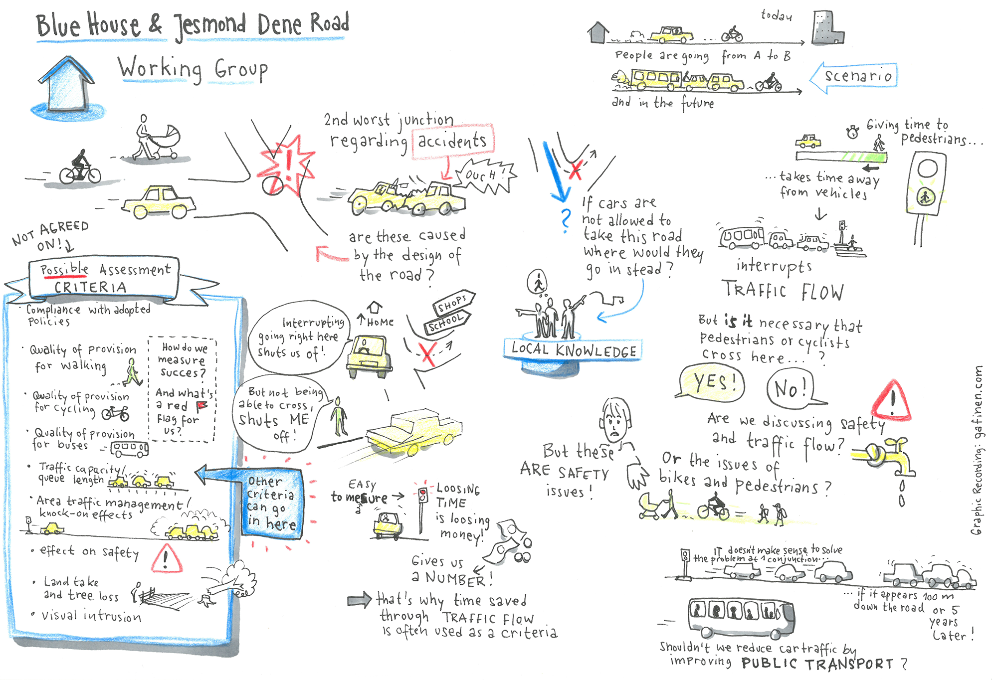
The graphic covers the issues of safety and conflict. SPACE would have liked Public Health and Pollution to have been included in the graphic as well. However, to be fair to Marie, the topic didn’t receive the same attention as Safety and we spent a lot of time looking at previous plans and the reasoning behind them.
Newcastle City Council also presented several alternative plans that they had considered for the Blue House junction, some of which can be viewed on the Blue House website. If you have any questions about these documents, you can post them on the site for Newcastle City Council to answer.
The meeting also discussed measures or tests of success for future proposals. This is an important issue at the Blue House junction as it has a poor safety record (the second worse junction in the City), and the Council has a duty of care to improve it. In short, doing nothing is not an option.
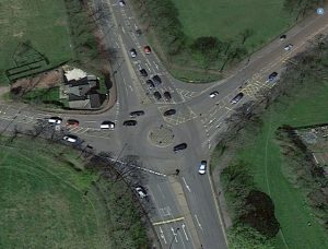 This is what we have at present:
Although there are some pedestrian and cycle paths leading to the junction, the actual pedestrian and cycle crossings on the junction are poor. If these can be improved, this will not only make travelling safer for pedestrians and cyclists, but is likely to lead to an increase of people travelling across the junction by these means, as it will become safer for children and less confident cyclists.
In the meeting the following were identified as key measures of success for an alternative design:
- Compliance with adopted policies
- Quality of provision for walking
- Quality of provision for cycling
- Quality of provision for buses
- Traffic capacity / queue lengths
- Area traffic management / knock on effects
- Effect on safety
- Land take and tree loss
- Visual intrusion
- Impact on Air, Noise, and Light Pollution (added by SPACE)
- Volume of vehicles (added by SPACE)
SPACE will provide a series of blogs which address each of these points over the next two weeks and seek your feedback. In the meantime, SPACE is in the process of discussing with the Digital Civics team how we can better engage with SPACE members and the wider community. We’ll keep you posted.
You can find our round-up of the first Working Group meeting here and Newcastle City Council’s roundup here.
The date of the next meeting is Monday 31st October 2016
If you have any questions or comments, you can email SPACE at spaceforgosforth@gmail.com, leave comment on this post, make comment on our Facebook page or add comment to the bluehousegroup.org posts.
Thanks for the post. A few comments on the success factors:
You have a identified a number of criteria to assess movement handling of a new junction design – some in qualitative terms (quality of provision for walking /cycling / buses) and some in quantitative terms. The quantitative criteria are “Traffic capacity / queue lengths” and “Volume of vehicles”.
“Traffic capacity / queue lengths” are measurable but what is more relevant to people’s journey is the time taken to transit the junction. Could that measurement be added to the list (or even replace Traffic capacity / queue lengths)? You would need to look separately at time taken for a person to transit the junction by each mode ie on foot, by bike, by bus/taxi, by car/van. The weakness of the design previously issued by the council was that someone on foot or by bike would have needed to make 4 separate crossings (waiting at each !!) to cross just one road.
“volume of vehicles” is a useful but limited measure as it doesn’t take account of the fact that some vehicles (buses) carry large numbers of people, but most vehicles (cars) usually carry just one. If you used ‘volume of people’ instead or as well as ‘volume of vehicles’ you would be able to quantify the effect of designs which gave more or less priority to buses. People also transit the junction by bike and by foot. Could/should we quantify those volumes? (noting that there is a separate intention to provide better cycle routes and that this will lead to an increase in numbers of people on bicycles, and the better the crossings at Blue House for people on foot or by bike, the more people will go on foot or by bike )