
At the SPACE for Gosforth public meeting in Trinity Church we outlined how the size of the Blue House roundabout was due to a predicted increase in vehicle traffic; and how an alternative that prioritises helping people get about on foot, by cycle and public transport could be a viable alternative that meets Newcastle City Council’s objectives and saves the Town Moor.
This post is our feedback to the Blue House to Haddricks Mill scheme. You can comment on these proposals up to Sunday 21 August on the Council’s Commonplace website.
Dear Mr Grant,
This is the feedback from SPACE for Gosforth on the Blue House to Haddricks Mill proposals. SPACE for Gosforth is a group to promote and campaign for a Safe Pedestrian and Cycling Environment for Gosforth. We are residents of Gosforth, most of us with families and we walk, cycle, use public transport and drive. We are not affiliated to any other campaign group or political party. We want to see Gosforth as a destination for visitors rather than purely a transport corridor. We want to see changes to Gosforth’s road infrastructure that prioritise people walking and cycling of all ages and abilities over vehicles.
Under normal circumstances SPACE for Gosforth would not comment as a group on these proposals, however due to the exceptional nature of the plans proposed and their negative impact upon the City of Newcastle, particularly with regard to public health, we felt that it was important to do so.
As a group we recognise and support the need for people to get about, and we are pleased that Newcastle City Council has objectives to reduce congestion, improve safety and to reduce air pollution and its impact on public health. We see that there are positives in the schemes proposed, especially the bus and cycle lanes on Killingworth Road and the new pedestrian crossing at the end of Osborne Road.
However, there are also a great number of negatives as well and our considered view is that under the current proposals, none of these three objectives are likely to be met; and that this scheme, as it stands, represents poor value for money.
We would like to propose amendments both to the schemes and the underlying assumptions made by Newcastle City Council. We believe these would result not only in this scheme being value for money; but would also lead to a significant return on the Council’s investment.
Blue House – Vehicle capacity and loss of green space on the Town Moor
The most significant feature of the Blue House proposal is the size of the roundabout. This we understand is as a result of the Council’s modelling assumptions relating to the level of demand for travel, what those journeys will be and how they will be made. We would like to challenge all three of these assumptions.
25 years of research shows that a junction designed with significant additional capacity will cause additional traffic due to induced demand, and this extra traffic will negate any time savings or improvements in air quality that may be forecast.
This additional traffic will be nothing to do with any increased economic activity or the new homes currently being built in Newcastle’s green-belt. While economic activity may lead to some additional journeys being taken, there is little evidence that increasing capacity for travel increases economic activity. It is more likely that more journeys (and therefore more cost) will be made at the same level of activity. This would represent a loss of productivity for the region.
People’s decisions as to where they live and travel to will be influenced by the additional capacity being provided. This scheme will therefore encourage more people to live outside Newcastle, potentially weakening local neighbourhoods, and to make longer journeys – undoing any benefit of time savings predicted for this junction. This contradicts Newcastle City Council’s own strategy for stronger, healthier neighbourhoods.
The assumption of how we travel is most important though. Walking, cycling and public transport are extremely space-efficient means of travel and with a different mix of transport modes, the same or greater numbers of people could travel through these junctions but in a fraction of the space required by the proposed roundabout, and at a fraction of the cost. We are glad to see so many of the comments on Commonplace support making improvements for these modes. Improving conditions for walking, cycling and public transport will also induce demand, but in a way that benefits the whole community.
Further, the desired mix for how we travel is part of Newcastle City Council’s own strategy and if such schemes do not support that mix of travel then it will not be possible for Newcastle City Council ever to achieve the strategic objectives it desires. At the same time we expect Newcastle City Council to work with developers on the new estates and business parks to ensure that people who will live or work there will have a good range of travel options in line with the Council’s strategy including walking, cycling and public transport.
Blue House – Issues with the design
- As stated, the increased vehicle capacity will induce traffic. Based on transport research evidence, the likely result of this will be additional air pollution, road safety issues and congestion in surrounding areas. Any benefits to journey time are also likely to be short lived. Air pollution is a significant concern at the Blue House Roundabout, as this junction is within the South Gosforth Air Quality Management Area. Any increase in traffic at this junction is therefore inappropriate due to the increased risk to public health.
- The Town Moor is part of Newcastle’s brand and part of what makes the city special. This is an inappropriate use of that space.
- It is known that poorly designed pedestrian and cycling facilities are not used as they were intended. The routes proposed for people walking and cycling require multiple multi-stage crossings and as a result people will react by finding alternatives ways of crossing this junction. This may be to drive instead, or pedestrians may not wait for traffic to stop. Cyclists may ride through the junction rather than wait for the lights. All three reactions put people at greater risk and would negate the intended safety benefits.
- There appear to be no changes that improve conditions for or prioritise buses travelling through this junction. For most of the day, when traffic is not at its peak, the additional distance to travel through the junction and multiple traffic lights will result in a slight slowing of journey times, which when multiplied across the day could become a significant issue for bus operators.
Blue House – Improvements
We would like to see a junction designed to fulfil the following objectives:
- A design that encourages walking and cycling through safe, direct and comfortable routes separate from each other and both separate from vehicle traffic. The Dutch approach to roundabout design is worth considering in this regard in light of its good safety record and demonstrable success in creating routes that people actively choose to use. We consider that people may support the routing of these paths either through the trees, or on the other side of the trees from the junction, if this is done sensitively and only for as far as necessary due to junction design considerations – provided that this results in the vehicle junction being confined within the existing footprint.
- Bus priority leading up to the junction to be included in the design to improve bus journey reliability.
- The existing junction footprint to be used as a guide for the appropriate maximum capacity for this junction, as would be standard practice for any other urban junction.
- As stated in the FAQ released by the Council, the best way to encourage cycling is through a network of good quality routes. The same is likely to be true of walking. The routes through this junction should therefore be linked to footpaths and cycleways that traverse the length of the Northern Access Corridor from Cowgate in the west to Killingworth Road and Benton Park Road in the North so that those that wish to use this route have a full set of choices for how they do so.
- Traffic lights could be installed if desired on the roundabout, to be used as peak times to control the throughput of traffic from the dominant arms.
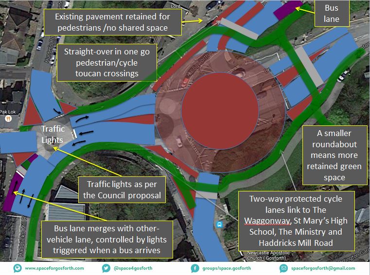
The additional capacity created in this way will ensure the maximum throughput of people possible in the space that is available. The following graphic illustrates our suggested improvements.

Blue House – Conceptual Design
Jesmond Dene Road – Issues with the Design
- Existing traffic issues in High West Jesmond (especially on Ilford Road and Moorfield) that relate to a high volume of through-traffic and a high proportion of that traffic travelling in excess of the speed limit are not addressed in the changes proposed for that area.
- There are no safe cycling routes. In particular there is no safe connection between the Little Moor and Jesmond Dene. This proposal will not fill this gap.
- This proposal will result in the loss of the 33/33A bus linking Gosforth and Jesmond.
- Poor linkage between Gosforth and Jesmond as a result of Jesmond Dene Road acting as a barrier is not addressed by this proposal, and an increase in vehicle traffic may exacerbate this problem.
- This proposal has potential for additional through traffic to be generated on currently quiet Jesmond roads, particularly Highbury which is marked as cycle route.
Jesmond Dene Road – Improvements
We would like to see improvements for Jesmond Dene Road to be designed to fulfil the following objectives:
- We would like Newcastle City Council to consider ways of reducing through traffic in High West Jesmond as an alternative to banning the right turn out of the end of Moorfield and the proposed one-way across the Moorfield Metro bridge. This approach, some options for which we included in our presentation on the SPACE for Gosforth website, must be agreed in consultation with the local community. It would both reduce the interruptions to flow on Jesmond Dene Road and also resolve existing traffic issues in High West Jesmond.
- Safe protected cycling routes to be provided along Jesmond Dene Road to link to Blue House roundabout and onwards to Haddricks Mill. Our measurements of this road suggest that there is sufficient space is available to do this and to maintain the existing traffic lanes and pavement. It may be possible to provide this as a bidirectional route on the south / east side of the road given there are only two main junctions and relatively few houses on that side.
- This route should also support pedestrians and cyclists crossing from Moorfield to the part of Jesmond Dene Road that goes to the Jesmond House Hotel and to Crossway in Jesmond.
- We would suggest that the right turn to Osborne road is maintained. With more people walking, cycling or using public transport the need to remove this should be reduced. At the very least we would like to see the right turn retained for the 33/33A bus route.
- Appropriate measures will be required on Forsyth Road, Highbury and potentially other nearby routes to ensure they remain safe for walking and cycling in light of any changed traffic patterns.
Haddricks Mill Road
Although not included in the current proposals this forms part of the Northern Access Corridor route and we would like to suggest a number of improvements that we would like the Council to consider alongside our other feedback:
- Walking and cycling routes, as stated above, should continue for the length of this road. This could mean reducing splay widths and narrowing junction entrances to make roads easier to cross on foot and to reduce the speed of turning traffic.
- Parking that is currently on the pavement and impedes the footpath should be relocated to the road to ensure a clear path for pedestrians.
- The current south-bound cycle route that is routed in a ‘dooring’ zone should be relocated to be separate from vehicle traffic.
- The entrance to Castles Farm Road needs proper pedestrian facilities as there is currently no pavement and is unpleasant to use, especially in the dark.
- Measures such as narrower road lanes should be taken to encourage slower vehicle speeds to (a) improve safety for people crossing; and (b) reduce starting and stopping traffic that increases pollution.
Haddricks Mill Junction – Issues
- As at Blue House, the design of walking and cycling paths using multiple crossings and round-about routes will not be practical or attractive to pedestrians and cyclists and is likely to lead to unintended behaviour which will negate much of the safety benefit.
- Shared space for pedestrians and cyclists is uncomfortable for both and could discourage people from walking or cycling.
- Under the current design, vehicles can enter and exit the roundabout at high speeds which will mean any collisions could potentially be serious or worse.
- The non-standard design with filter lanes is likely to confuse people who do not use this junction regularly – exactly the issue with the current layout that these proposals should be seeking to fix.
- Improving access to the Coxlodge Waggonway (an important route for both cycling and walking in Heaton) is not included in these plans, even though it ends at Haddricks Mill, and the current entrances are awkward for cyclists, and for those using buggies and wheelchairs.
Haddricks Mill – Improvements
We would like to see a junction designed to fulfil the following objectives:
- The roundabout should be designed to a more traditional layout, to make it easier to navigate by drivers who are unfamiliar with its layout.
- To make the roundabout safer, entrances and exits to the roundabout should be narrower and more perpendicular to the roundabout. These would result in drivers entering and leaving the roundabout at lower speeds.
- Separate protected routes should be provided for both pedestrians and cyclists, to make traversing the roundabout safer and more pleasant for both.
- The walking and cycling routes round the junction should connect to the Coxlodge Wagonway as well as onwards up Killingworth Road and Benton Park Road to Benton Park View and St. Mary’s High School to encourage people travelling to these destinations to walk or cycle.
- Haddricks Mill is an important transport junction for all modes of travel as it is one of the few crossings of the historic Ouseburn Valley. Haddricks Mill also has value as a place as is next to a conservation area, includes some green space and has a number of old buildings adjacent to it. A design sympathetic with these characteristics, which reduces the loss of green space, would be beneficial.
- We would suggest in light of the size of the junction that the encircling cycle route is two-way so that people cycling can, like those walking, always choose the shortest route.
- Bus priority on the approach from Haddricks Mill Road would assist with bus journey reliability.
The following graphic illustrates our suggested improvements.
Haddrick’s Mill – Conceptual Design
Station Road – Issues
- Station Road itself is a poor environment for people walking or cycling, and this is not addressed in these proposals.
- The proposed location for new parking spaces would require some considerable widening of that area resulting in the loss of trees and part of the green to the north of Station Road.
- By reversing the direction of one-way travel on the back alley there is a risk that vehicle traffic will use this new cut through to bypass queuing traffic on Station Road.
- The quiet location of the proposed parking may lead to some people not using it for fear of crime.
Station Road – Improvements
We would like to see alterations to Station Road designed to fulfil the following objectives:
- An alternative location for parking might be on the east side of Hunters Road next to the grassed area (see illustration below). This must be agreed in consultation with local residents. It would not provide as many spaces however traders could continue to use their existing parking in the back lane so fewer spaces would be required. Restrictions limiting parking in the proposed area on Hunters Road to 1 or 2 hours during trading hours may be appropriate ensure that this parking is used as intended to support the Station Road shops.
- As Station Road is a poor environment for walking and cycling we would like to suggest a shared walking / cycling path going from Station Road north of the row of shops along the edge of the green dipping into the back lane by Hunters Road. This would not attract faster cyclists who would prefer the quicker more direct route however it would improve the experience for the majority who do not enjoy cycling in traffic.
- Moving the current pedestrian crossing slightly to the west would assist with people walking or cycling who wish to access this path from Audley Road.
- We would also suggest the inclusion of cycle parking next to the shops on the north side of the road.
The following graphic illustrates our suggested improvements.
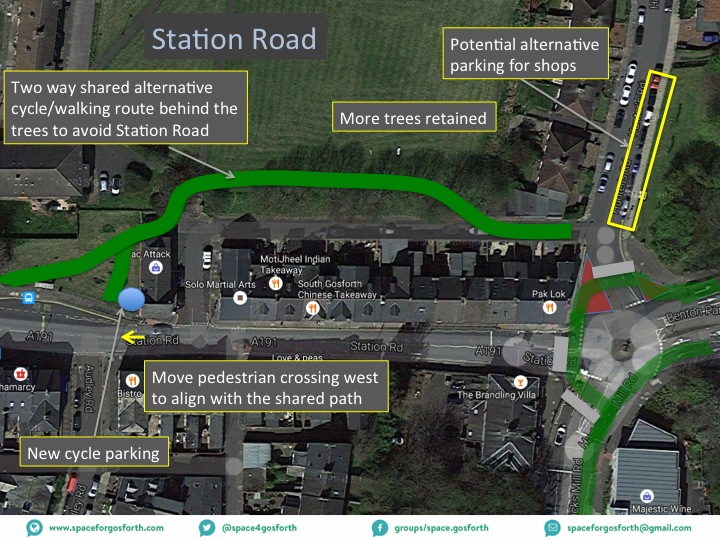
Station Road – Conceptual Design
Killingworth Road / Salters’ Lane Metro Bridge
We support the changes being made here to include a bus lanes and cycle path as well as to widen the pavement.
In summary, while we note that there are many negatives to the currently proposed schemes, with the improvements listed above alternative schemes may be presented that meet Newcastle City Councils’s objectives of increasing people-moving capacity, improving safety for all users and reducing air pollution by encouraging more people to walk, cycle or use the bus. Our alternative scheme would also avoid the need for banning movements, in particular for the number 33/33A bus route, and the loss of green space on the iconic Town Moor.
Yours faithfully,
SPACE for Gosforth.